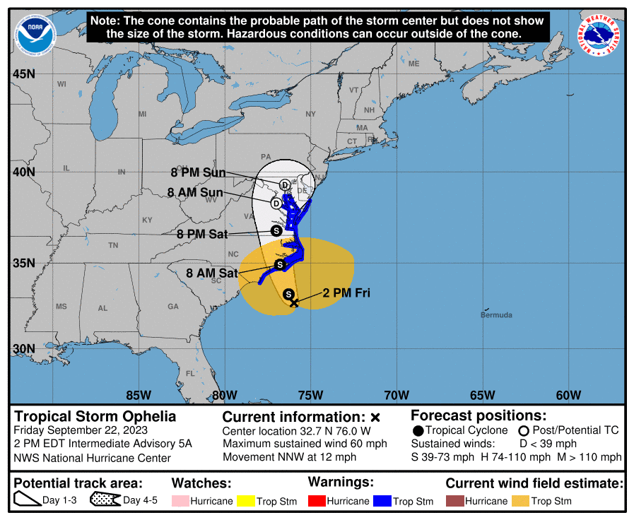
2 p.m. Friday update:
Potential Cyclone 16 has been named Tropical Storm Ophelia, according to the 2 p.m. Friday update from National Weather Service’s Newport office.
Supporter Spotlight
Forecasters said that expected impacts, including storm surge, wind, heavy rain, and tornadoes have not changed since earlier updates.
Tropical Storm Ophelia is about 180 miles south of Buxton or about 150 miles south-southeast of Morehead City, moving north-northwest at 12 mph.
A storm surge warning and tropical storm warning are in effect for Beaufort, East Carteret, Hatteras Island, Mainland Hyde, northern Outer Banks, Ocracoke Island, Pamlico and southern Craven counties.
A tropical storm warning and storm surge watch are in effect for Coastal Onslow, Mainland Dare, Tyrrell, Washington and West Carteret counties.
“Tropical Storm Ophelia will continue to strengthen as it moves toward eastern North Carolina this afternoon and tonight. Regardless of development, moderate to locally significant impacts will occur across eastern North Carolina, with the greatest impacts along the coast,” forecasters said.
Supporter Spotlight
11 a.m. Friday update:
Portions of the Outer Banks, Down East Carteret County, Morehead City and the National Weather Service’s Newport office are already seeing moderate rain from potential tropical cyclone 16 off the coast, and will only increase throughout the day.
As the storm center approaches Friday night, the rain may become more scattered, “but we’re getting into some of those heavier bands of rainfall today,” Warning Coordination Meteorologist Erik Heden said during a 9 a.m. Friday webinar update. “Right now, it’s a potential cyclone. It is still expected to be a high-end tropical storm as it approaches our coastline sometime late tonight, more likely tomorrow morning.”
At 11 a.m. Friday, forecasters said the potential cyclone is about 200 miles south of Cape Hatteras with a maximum sustained winds of 50 mph. The storm is moving north at 12 mph.
“A north to north-northwest motion is expected during the next couple of days. On the forecast track, the center of the low will approach the coast of North Carolina tonight, and then move across eastern North Carolina, southeastern Virginia, and the Delmarva Peninsula Saturday and Sunday,” the 11 a.m. update states.
A storm surge warning is in effect for Beaufort Inlet to Chincoteague, Virginia, Chesapeake Bay south of Colonial Beach, Virginia, the Neuse and Pamlico rivers, and portions of Pamlico and Albemarle sounds.
A tropical storm warning is in effect for Cape Fear area to Fenwick Island, Delaware, the Albemarle and Pamlico sounds, Tidal Potomac south of Cobb Island, and Chesapeake Bay south of North Beach.
A storm surge watch is in effect for Surf City to Beaufort Inlet and remainder of Pamlico and Albemarle sounds.
Into Saturday, the system is expected to produce 3 to 5 inches of rainfall across eastern North Carolina, with some areas seeing up to 7 inches, and could produce flash, urban, and small stream flooding impacts.
A few tornadoes are possible beginning Friday through Saturday for portions of the mid-Atlantic Coast.
Heden said that forecasters have noticed there’s a lot of lightning over the center of the storm in the last four hours, which indicates the storm is probably strengthening.
“Despite the landfall being Saturday morning, keep in mind these tropical storm force winds especially in the form of gusts approach our area by late this morning,” he said, adding to expect water levels to increase today as winds become stronger.
2 p.m. Thursday update:
Forecasters expect possible impacts for eastern North Carolina from potential tropical cyclone 16 to include heavy rainfall, gusty winds, and isolated strong to severe thunderstorms.
National Weather Service officials in the Morehead City office said at the 2 p.m. Thursday briefing, a tropical storm warning is in effect from the Cape Fear region to Fenwick Island, Delaware, Albemarle and Pamlico sounds and Chesapeake Bay south of Smith Point.
A storm surge watch is in effect for Surf City to Chincoteague, Virginia, Chesapeake Bay south of Smith Point, and the Albemarle and Pamlico sounds.
Potential tropical cyclone 16 is about 430 miles south of Cape Hatteras with maximum sustained wind of 35 mph.
The system is moving north at close to 9 miles per hour, and is expected to continue on the same path through early Friday. The system is expected to strengthen during the next day or two, and is forecast to become a tropical storm as it approaches the coast of North Carolina.
“On the forecast track, the center of the cyclone is expected to approach the coast of North Carolina within the warning area Friday night and early Saturday,” officials said.
Officials said that regardless of whether the system becomes a tropical storm, the system is expected to bring tropical-storm conditions to portions of the southeast and mid-Atlantic coasts.
The following are the latest key takeaways provided by National Weather Service officials for all of coastal North Carolina on the approaching storm:
- Storm surge inundation around 2 to 4 feet above ground is possible across coastal areas, particularly around the lower Pamlico and Neuse rivers.
- Tropical storm force winds are possible along the east of U.S. 17, with scattered tree damage and power outages possible. The strongest winds are expected to extend from Cape Lookout area across the Outer Banks.
- The widespread rainfall of 2 to 4 inches, with locally higher amount of up to 6 inches, could result in flash flooding issues, especially around urban and poor-drainage areas, in all of eastern North Carolina.
- A few tornadoes could bring locally enhanced damage, along with power and communications disruptions, mainly across the Outer and Inner banks and Down East Carteret County.
- Life-threatening surf conditions and dangerous marine conditions continue through the weekend.


