CARTERET COUNTY — Boaters unfamiliar with the waters around Harkers Island and Cape Lookout National Seashore can quickly get into a lot of trouble, and that’s happening more and more.
The risk of running aground near Cape Lookout is nothing new and even seasoned skippers have discovered the perils.
Supporter Spotlight
“Anybody who says they haven’t run aground in Core Sound is a liar,” Cape Lookout National Seashore Superintendent Jeff West told Coastal Review last week.
West describes the area as “constantly shoaling and just not very deep,” and he emphasized that it’s particularly dangerous for the unfamiliar.
“Typically, that’s the person we see getting into trouble,” he said.
Mariners say the channel here moves with nearly every tide and storm and locals advise those unfamiliar with these waters to avoid the area.
Karen Willis Amspacher, a lifelong resident of Harkers Island and executive director of the Core Sound Waterfowl Museum and Heritage Center, said the best course is to rely on professionals to get to Cape Lookout.
Supporter Spotlight
“If you don’t know your way to the cape you might as well just stay home or you’ll spend the day shoving,” she said last week in an interview.
Capt. Peter Koltun of Sea Tow Crystal Coast explained to Coastal Review that more and more boaters are finding trouble here. Sea Tow provides marine towing and on-water assistance.
“We’ve had a huge increase in jobs in that area,” Koltun said. “The channel is getting skinnier and skinnier.”
Koltun and others said the Barden Inlet Channel, including a segment long known as “The Drain,” had become so “bottlenecked” there’s no room for even the slightest error. One wrong turn and “it goes from 6 feet at high tide to 2 inches at high tide,” Koltun said.
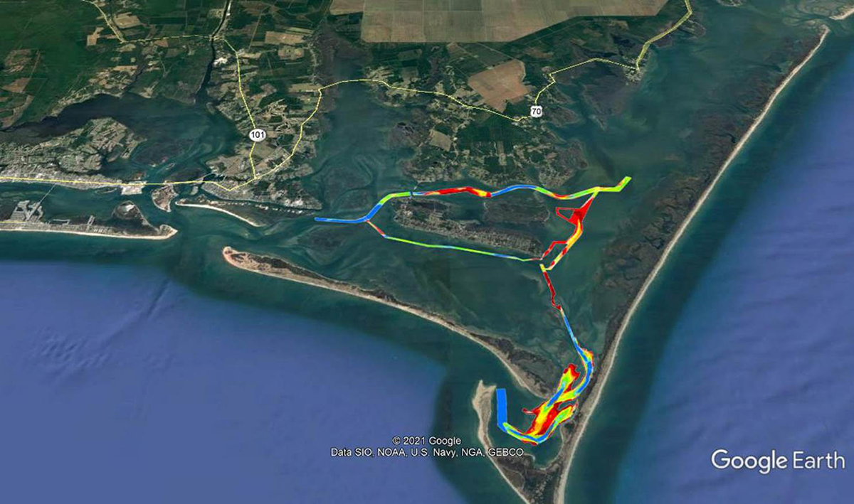
The only way to get to Cape Lookout is by boat, via the Barden Inlet Channel, which is a federally authorized channel although it’s not maintained and is no longer marked. Federal funding for dredging here hasn’t been available since the 1970s. The remaining aids to navigation in Barden Inlet were removed late last year after conditions were deemed too unstable and unsafe.
West said providing safe access to visitors is paramount, but the park service can’t do it alone.
“The National Park Service has not taken responsibility for this in the past, and for good reason: Most of the channels are outside our boundaries,” he said.
Capt. George Aswad is operator of Crystal Coast Lady Cruises and the Lookout Express, the park service-authorized ferry service to Cape Lookout and Shackleford Banks with round-trip service from Harkers Island and Beaufort.
“We transit (the area) every day, so we’re used to it. It does change and it’s changing as we speak,” he said. “The worst is The Drain, or the S-curve, near Morgan Island. It gets pretty shallow there, but a new channel is opening on the north side of it and that’s getting deeper every day.”
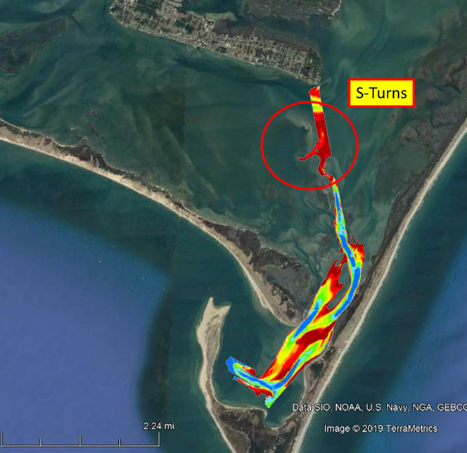
“The Drain” and the “S-curve” are parts of a series of channels that comprise the South Core Banks/Lookout Bight Channels. The congressionally authorized channel to Back Sound and Lookout Bight, which extends from Harkers Island to the bight itself, incorporates the severely shoaled S-curve or S-turns area.
The National Park Service administers the remaining channels, including the Great Island Ferry Channel, the Lighthouse Channel, Les and Sally’s Channel, and the Shackleford Dock Channel.
When shoaling in the federal channel reached a critical stage, that was when the Coast Guard removed aids to navigation.
Aswad said his ferries make 20 round trips per day between Shell Point at Harkers Island and Cape Lookout and Shackleford Island. He sees boaters get into trouble all the time.
“A lot of private boats come through there at full speed, not knowing where they’re going, and we watch them go aground at full speed. Plenty of times we yell at them trying to get them to slow down,” he said. “Most of the time, the private boats follow us. We gladly help everybody and let them follow us through there, that’s not an issue at all.”
Aswad said more common sense and courtesy on the water could help the situation all around, but he and others agree, Barden Inlet needs attention.
The Coast Guard recently announced changes to aids to navigation in nearby waterways, including Shackleford Slue and the Middle Marshes, Harkers Island Channel West and Core Sound Channel, which are regarded as improvements. But it’s uncertain when fix for the federal channel is coming, although the money for dredging is available.
Cooperative management agreement
Greg Rudolph is manager of Carteret County’s Shore Protection Office. He oversees beach nourishment projects in the county, projects that generally use sand from channel dredging, and serves as the county’s principle liaison with the Army Corps of Engineers and other agencies on related issues.
Rudolph explained that, although the channel is federally authorized, federal funding for its maintenance has not been a priority because use of the inlet these days is mainly recreational. But that’s no excuse, Rudolph said.
“If you were going to the Grand Canyon and there was an avalanche at the only way to get into the Grand Canyon, there would be funds for that,” Rudolph said.
So, to secure funding, Carteret County officials in July 2019 struck an agreement with the National Park Service to cooperatively manage waterways serving park service properties.
The deal set the terms and conditions for the county to accept funding from the park service to put up as the required match for grants from the state’s Shallow Draft Navigation Channel Dredging and Aquatic Weed Fund. Revenue for the fund comes from fees for boat registrations and title transfers. Approved projects must be paid for with at least one non-state dollar for every $2 from the fund.
During the first year of the agreement, the park service provided $590,554 to the county, which, along with money from the Shallow Draft Fund, resulted in a total $1.77 million provided to the Corps of Engineers. In 2020, the park service provided an additional $1.3 million to the county, which again leveraged with the Shallow Draft Fund resulted in another $3.9 million contribution to the Corps for a total of more than $5.67 million to cover costs associated with preparing an environmental assessment with a finding of no significant impact needed to secure the necessary permits and authorizations and most of the dredging expense.
Now, county and park service officials are waiting for the Corps to formulate the project
“That is the key to solving this for the long term,” West with the park service said. “It’s the only way to keep the channels open and it will allow long-term, joint management of the waterways and systems with some federal money.”
“The biggie for everybody is Barden’s Inlet,” West added. “Once the environmental assessment is done, they can get started, and we’re including all the waterways in this area in the environmental assessment to get the compliance out of the way.”
He said that Barden Inlet is the priority, but dredging that channel will bring multiple benefits, including helping to lessen erosion problems in front of the Cape Lookout Lighthouse.
“There is a reason they call it The Drain, here locally. Once it’s opened up, it will do its job,” West said.
But, he added, there are decisions that can only be made once the environmental assessment is complete.
“We don’t want to do the wrong thing, and sometimes putting a dredge in the same spot, it just fills back in. It might be smarter to take advantage of some of the naturally deeper water, but there might be legal ramifications. Half of any of these battles is getting the process started and we’re about halfway through the battle.”
Officials with the Corps of Engineers’ Wilmington District had not responded Tuesday to a request last week for comment on the status of the environmental assessment.
Changes in adjacent waters
In nearby waterways, the Coast Guard is changing 25 aids to navigation near Shackleford Banks and Harkers Island, changes officials say were needed because of dangerous conditions that are getting worse.
The changes were set to begin earlier this month for Shackleford Slue and the Middle Marshes, Harkers Island Channel West and Core Sound Channel.
The Coast Guard said the intent is to make the lateral aids — the red and green buoys — more readily comply with the “red, right, returning” direction of travel in an area where there are several converging channels from sea and around various barrier islands.
Chief Warrant Officer Chris Winters, the officer in charge of aids to navigation for waters served by Coast Guard Station Fort Macon, told Coastal Review that the significant changes were “in response to worsening conditions in Core Sound, the heavy flow of recreational vessel traffic from Beaufort Inlet to Taylor’s Creek via Shackleford Slue and to make the waterway easier to understand for mariners not familiar with the area.”
Winters said the latest changes were not associated with the removal of aids to navigation in Barden Inlet, which was completed late last year after conditions were deemed unstable and unsafe, although he said they do affect the adjacent waterways.
“The National Parks Service, Carteret County and the Army Corp of Engineers are actively working on funding dredging operations, once the dredging is complete the Coast Guard will assess channel conditions and replace (aids to navigation) as appropriate,” Winters said.
Rudolph agreed that the changes to aids to navigation have little to do directly with Barden Inlet or The Drain “or whatever you call that long channel reach from Harker’s Island to the lighthouse.” But numerous boaters who will benefit from the improvement to aids to navigation “and it is an improvement,” he said, are also using the Barden Inlet Channel, “so it’s almost marking a road to a dead end until we can get it dredged and navigable.”


