The state’s Environmental Management Commission will wait another two months before taking a vote on an updated water resources plan for the Chowan River Basin, which has seen a steady increase in toxic algae blooms over the past decade.
The EMC was poised to adopt the plan during its meeting last week, but after several members objected to a section of the plan highlighting the lack of data available to water quality analysis, the commission instead opted to delay a final vote until March.
Supporter Spotlight
Although the basin plan has already gone through a public input and extensive stakeholder process, the commission approved a last-minute revision that changes a section suggesting the need for a statewide water-use permitting program that would provide a clearer picture of water users.
North Carolina is one of only a handful of states that do not have a statewide permitting program for large-scale water users.

Commission member Donald van der Vaart, who was state environmental secretary during former Republican Gov. Pat McCrory’s administration, called the idea “a huge, huge leap” and something the North Carolina General Assembly had already cordoned off through legislation.
Van der Vaart said he didn’t see the need for additional reporting requirements.
“I’m not convinced we’ve got that kind of a need for that microscale, granular level of data that you are seeking,” he told Department of Environmental Quality officials Thursday during the commission’s online hearing.
Supporter Spotlight
Forest Shepherd, a basin planner with the Department of Environmental Quality’s Water Resources Division, told commission members it is difficult to determine what is happening in the river without finer detail in water use by agriculture operations.
State and federal confidentiality laws prevent details of use by individual operations. Instead, water use for agriculture operations is sent to the state Department of Agriculture and Consumer Services, which provides DEQ with aggregate use for the basin.
The aggregated data for the Chowan basin shows that agricultural use, including animal process uses account for about 3 million gallons per day, more than 30% of the total water usage in the basin.
Public and other local water suppliers make up the bulk of water use at 58% and about 7% of use is by manufacturing operations.
EMC chair Stanley Meiburg, said that while he agreed that the Chowan plan was not the place to debate the need for a statewide permitting program, he did see the need for more localized and timely information for tracking the river’s water quality issues other than just annualized data.
“That doesn’t really help you if you’re trying to do modeling of what’s causing what, to me, are pretty alarming outcomes with respect to these algal blooms,” he said.
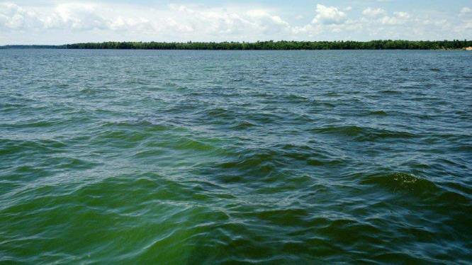
The Chowan River, which flows into Albemarle Sound, begins near the North Carolina-Virginia border at the confluence of the Meherrin, Blackwater and Nottaway rivers
About a fourth of the basin is in North Carolina and includes all or part of Bertie, Chowan, Gates, Hertford and Northampton counties.
According to a 2016 land use survey, about 36% of the basin is forest, 29% agricultural and 20% wetlands. The state requires plans for its major water basins to be updated every 10 years. The current update is aimed at addressing an increase in algal blooms, including some that have produced toxins harmful to humans.
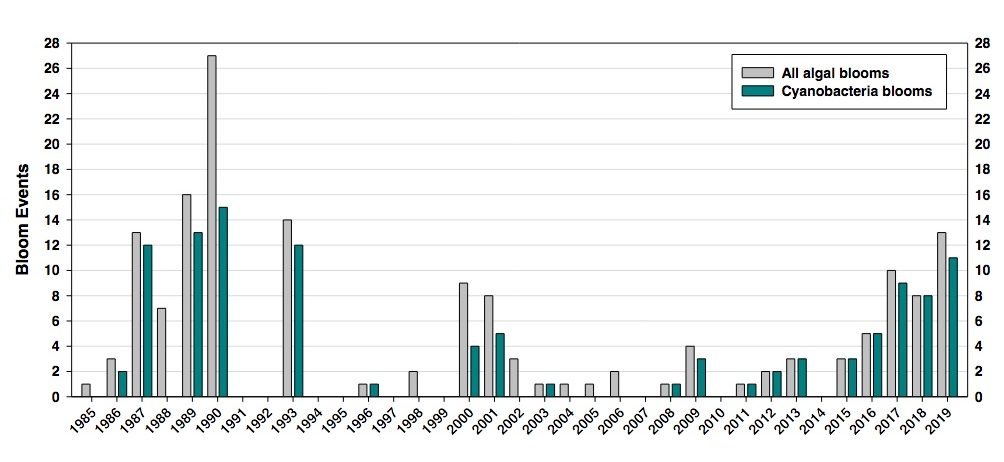
A DWR assessment in the plan shows algal blooms in the Chowan River steadily increasing over the past several years, with many located near Colerain, Edenton and Arrowhead Beach. DWR logged two major blooms in 2015, three in 2016, five on 2017, seven in 2018 and 18 in 2019, when state health officials issued six health advisories to avoid the river because blooms were producing toxins hazardous to people and pets.
The new revisions to the basin plan tone down advocacy of a new permitting program but still highlight concerns about data gaps on water usage.
The report also highlights a lack of information about the impact of poultry operations, including how much land in the basin is being used for poultry operations’ dry-litter waste disposal.
DEQ officials told commission members that because poultry operations operate without the same permitting requirements as other animal operations, there is no information on how and where waste is handled.
The basin plan calls for additional information on poultry operations and land application sites in order to establish new monitoring stations and assess potential nutrient impacts.
EMC commissioner Marion Deerhake said the motivations for the request for specific information on operations were driven by the need to understand where new nitrogen loads in the river are coming from.
“Understanding the dynamics of the new chemistry, new nitrogen loads is, I believe, what’s motivating staff to seek additional information,” she said. “Those loads include making sure that we have properly used the existing system to collect information from animal operations, where the mass of the nutrients that are generated are moving out, where they’re being currently managed, where the most sensitive sub-basins are, areas vulnerable to harmful algal blooms.”
Heather Deck, executive director of SoundRivers, a nonprofit watchdog group for the Neuse and Tar-Pamlico rivers, said the Chowan River basin is a unique watershed with a lot of possible factors affecting the nutrient load, from runoff to industrial sites.
“The blooms on the Chowan are so much more severe than what we see in the Pamlico or on the Neuse, but I think there’s a lot of questions as to why,” she said in an interview with Coastal Review. “It’s clearly a very rural watershed, and so there’s a lot of nonpoint source-type runoff and there’s been an explosion of poultry, as we’ve seen in other places.”
She said the pushback against gathering more detailed information is concerning, because basinwide plans are supposed to be an opportunity to lay out concerns and what might be missing in the way of information.
“These basinwide plans are supposed to be the opportunity to describe: Here’s what we know, here’s what we don’t know and here’s what we think needs to happen, so that managers have the information to ensure that they’re protecting these resources and they’re required to do.”
The full plan and recommendations are available online.
Below is a DEQ story map on the Chowan River Basin.


