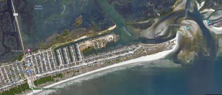
SUNSET BEACH – The town has received a state permit to dredge south Jinks Creek to less than half of the depth the town requested in its permit application.
The North Carolina Division of Coastal Management earlier this week issued a conditioned Coastal Area Management Act, or CAMA, major permit that limits the dredging depth in the southern portion of the creek, feeder channel, finger canals and bay area of the island to no more than 2 feet below mean low water.
Supporter Spotlight
Sunset Beach’s dredging plan proposes to excavate those waterways, with the exception of the finger canals, to 6 feet below mean low water. The finger canals would be dredged to a depth of 5 feet.
Town Administrator Hiram Marziano II said the town will ask the Coastal Resources Commission, or CRC, for a permit variance.
“The CRC may issue a variance and amend the conditions of our permit to allow us to dredge deeper without disturbing adjoining areas,” Marziano wrote in an email distributed to property owners on Tuesday. “This process will take several months leading into early 2020 to Spring 2020 before we have a final decision from the CRC.”
Meanwhile, the town awaits word from the Army Corps of Engineers, which determined the town would have to apply for an individual federal permit rather than a general permit to dredge.
The Corps accepted public comments on the proposed project through Oct. 24.
Supporter Spotlight
Corps officials will evaluate those comments and allow Moffatt and Nichol, the engineering firm hired by the town to oversee the project, to respond, according to Tyler Crumbley, deputy chief of the Wilmington district’s regulatory division.
Corps and U.S. Fish and Wildlife Service officials are discussing whether threatened and endangered species may be affected by the proposed project and identifying those species that could be affected.
The project calls for placing dredged sand onto 1,600 feet of the island’s ocean shoreline.
In July, the fish and wildlife service informed the Corps that the proposed sand placement “may affect, and is likely to adversely affect” five species of sea turtles, red knot, piping plover and seabeach amaranth.
If the Corps determines the project may likely adversely affect a listed species, the agency will ask for formal consultation with fish and wildlife service, a process that could further push back a permit decision.
Town officials had hoped to begin the project, which includes roughly 3 miles of waterway, this fall, to unclog channels that give boaters access to the Atlantic Ocean.
In his email to property owners, Marziano addresses a series of questions about the conditioned CAMA major permit.
He said that dredging to a depth of 2 feet will would decrease the longevity and effectiveness of the town’s project.
“The initial construction cost would also decrease, but the Town could expect to be dredging a lot more frequently to maintain navigation,” he wrote. “So over time the project costs may increase due to repetitive mobilizations.”
He said he does not know how often town would need to do maintenance dredging.
“This is unknown and will depend on how quickly this fills in and how much money is generated from the as yet implemented tax district for the affected areas the Town has been authorized to establish once dredging has occurred,” Marziano said.
The Division of Coastal Management, or DCM, early this year approved a CAMA major permit for the town to dredge Mary’s Creek and Turtle Creek.
But the division said Moffatt & Nichol would have to resubmit the application to dredge south Jinks Creek, the finger canals, feeder channel and bay area because it missed several pieces of information.
Last year, town officials opted not to dredge the northern portion of Jinks Creek, which has never been dredged.
Jinks Creek is roughly a mile long and connects Tubbs Inlet with the Atlantic Intracoastal Waterway, providing ocean access to property owners who live on the eastern end of the Brunswick County island.
The creek supports nearly 1,200 oyster species per acre, or a little more than 50,300 in total, between the Intracoastal Waterway confluence and the entrance to the feeder canal, according to a February 2018 survey conducted by Moffatt & Nichol.
That survey concludes that proposed dredging “may create impacts” to more than 12,000 oysters and disturb an estimated 10.72 acres within the creek between the ICW confluence and feeder canal.
The CAMA major permit issued Oct. 28 for that portion of the project specifies several conditions, including developing and implementing an oyster relocation plan.
That plan is required only for the authorized dredged footprint, said Patricia Smith, DCM and Division of Marine Fisheries communications director.
Specifics of the method in which the relocation will occur were not available at press time.
Dredging may not occur within 10 feet of coastal wetlands, between April 1 and Sept. 30, and sand may not be placed on the beach between April 1 and Nov. 15.
The permit expires Dec. 31, 2022.


