Updated March 1, originally published Dec. 10: The state Coastal Resources Commission approved Feb. 27 during its quarterly meeting held in Morehead City fiscal analysis and amendments to 15A NCAC 07H .0304 and .0305 for the Designation of Unvegetated Beach Areas of Environmental Concern and Measurement Lines.
OCEAN ISLE BEACH – The state Coastal Resources Commission during its recent meeting Nov. 28 gave the go-ahead to designate an unvegetated beach area of environmental concern, or AEC, for Surf City and North Topsail Beach, to remain in effect until stable and natural vegetation has re-established.
Supporter Spotlight
The action creates a clear boundary for oceanfront construction in areas where there is no stable and natural vegetation present, including areas that have suddenly lost vegetation because of a hurricane or other major storm, until vegetation returns.
Hurricane Florence washed away the primary frontal dune and the established vegetation at Surf City and North Topsail Beach, making it impossible to interpolate a vegetation line, Ken Richardson, shoreline management specialist with the Division of Coastal Management, told the CRC.
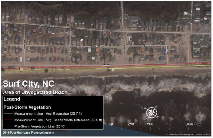
A measurement line cannot be established until an unvegetated beach AEC is first designated by the CRC. With that designation, Division of Coastal Management staff will be able to map a measurement line. The measurement line, which approximates the location where the vegetation line is expected to return and recover, is for the purposes of measuring oceanfront construction setback for new development, or for repairs exceeding the 50 percent threshold, according to the presentation.
Richardson explained to the CRC that after Hurricane Florence at these two locations, there was no vegetation on the ground to measure oceanfront setback, but the division cannot establish a measurement line without first having the unvegetated beach AEC.
Richardson asked the commission for guidance with interpreting the rules to establish the measurement line, or reference feature, for the purpose of measuring oceanfront construction setbacks in areas where there is no vegetation due to Hurricane Florence.
Supporter Spotlight
The two options are to calculate the average pre- and post-storm vegetation recession distance and measured that from the pre-storm vegetation line or calculate the average difference between pre- and post-storm beach width and measure that distance from pre-storm vegetation, according to the presentation. The two equations produce different outcomes, he said.
By asking for the commission’s interpretation of the intent of this rule, and with the unvegetated beach AEC in place, staff can map the measurement line based on commission’s interpretation of the rule, Richardson explained.
“What that means is that until they get vegetation growing again, staff would work on mapping the measurement line and as soon as they have vegetation they could measure set back from, they’ll default back to the vegetation line,” he said.
The CRC moved to interpret the rule to allow use of the recession from pre-storm measurement line as described in the rule and the interpretation is that the pre-storm beach width is used as the minimum distance for that recession line.


