EMERALD ISLE – There’s danger lurking in Bogue Sound, on and around a small, rapidly eroding island just off the end of 24th Street, where military officials are working to clean up years’ worth of unexploded ordnance and other material left by bombing practice flights decades ago.
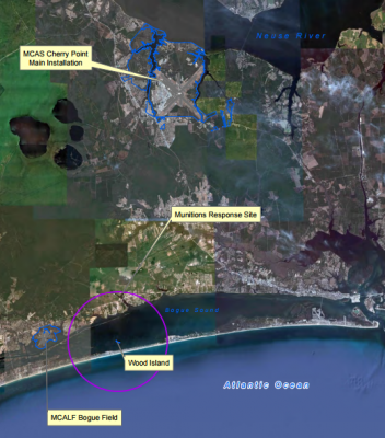
The Navy has been working with Marine Corps Air Station Cherry Point and the North Carolina Department of Environmental Quality to investigate, assess the risks and, starting again this month, remove potentially explosive material and inert metallic objects from tiny Wood Island. The effort is part of a sweep that takes place every three years or whenever a hurricane or tropical storm strikes this part of the North Carolina coast. The next cleanup is set to begin Feb. 21 and continue through about March 13.
Supporter Spotlight
Wood Island, which is less than 300 feet wide at its widest point and about 1,500 feet long, was used as a Navy bombing target in the 1940s and 1950s. The island is about a half mile north of Bogue Banks and about 1.5 miles south of the mainland. Although military documents refer to the site as the Cat Island Bomb Target BT‐2, the actual target locations were on and near Wood Island. Cat Island is about a mile and a half west of Wood Island and was never used as a bomb target.
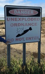
Although the island and the waters immediately around it are marked on nautical charts and surrounded with “Danger” signs warning of unexploded ordnance, there’s evidence people are going ashore, said Patricia Vanture of Naval Facilities Engineering Command Mid-Atlantic in Washington, D.C.
“As much as anyone can stay away from the area, they should,” Vanture said.
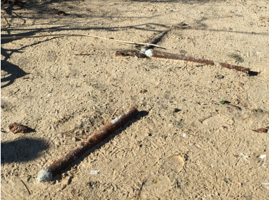
From 1943 to 1952, BT‐2 was used for bombing practice using inert, target‐practice munitions, according to Navy documents. The Marine Corps periodically removed “munitions and explosives of concern” and “material potentially presenting an explosive hazard” from the surface of the island while the bomb targets were in use in the 1940s and 1950s. The Navy began using live ammunition at the site in 1952, including air‐delivered bombs as large as 2,000 pounds. A report dated 2001 indicates that general-purpose bombs; armor‐piercing bombs; semi‐armor‐piercing bombs; depth bombs; rockets; and .30-caliber to 20 mm machine guns were used for training activities at BT‐2.
The Navy said the site hasn’t been used as a target since about 1955 and there are no plans to reactivate it. Munitions have been periodically removed from Wood Island since 1957, most recently in 2014.
Supporter Spotlight
“The Navy and Marine Corps have been investigating out there since the ’60s, so this is a long-term project,” Vanture said, adding that because BT-2 is a closed munitions site, the Navy has a responsibility to clean up.
Investigations have concluded there isn’t a human health risk from any chemicals at the site, “But because there’s certainly the potential safety risk from people coming onto the island, we do surface clearance where all they do is go out and pick up all the stuff they see,” Vanture said.
Explosive ordinance experts remove most material from the island to nearby Marine Corps Auxiliary Landing Field Bogue.
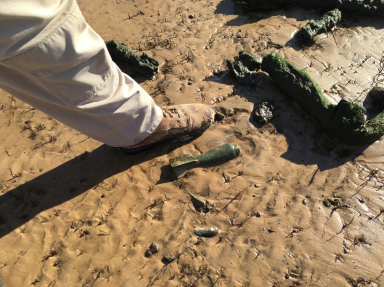
“If they actually find a live bomb, that will have to be detonated in place,” Vanture said. “It’s too dangerous to move.”
She said that in those cases, there will immediate efforts to alert the public before the detonation. Such action has been required in the past.
In 2010, a high-explosive, 100-pound, general purpose bomb was found during a cleanup and was subsequently detonated on Wood Island. Vanture said vibration monitoring was conducted at the time and nearby homes were not affected.
“That would happen again,” she said of the monitoring.
Frank Rush, town manager in Emerald Isle, said officials in the western Bogue Banks community have been notified when cleanups were scheduled.
“It really hasn’t caused any concerns or problems in Emerald Isle,” Rush said. “In my time as manager, I’ve never heard of it causing a problem for anyone there and previous cleanup efforts have gone smoothly. It’s a good thing to get cleaned up and I’m glad they’re coming back.”
In 2009, an aerial mapping survey was conducted over about 10 square miles of Bogue Sound surrounding Wood Island to detect and accurately map the locations of magnetic anomalies. The survey identified about 10,400 magnetic anomalies, with the highest concentrations clustered within about 650 feet of the island.
“This mass of closely spaced magnetic anomalies corresponds to the expected pattern of ordnance distribution for an aerial bombing target,” according to Navy documents.
In October and November 2010, MCAS Cherry Point and the Navy conducted an expanded search and removal effort to identify and remove munitions-related items and other metallic items from Wood Island. About 3,900 pounds of potentially explosive materials were removed from the island, along with 120 pounds of other metallic debris related to recreation and fishing activities in Bogue Sound.
In March 2014, Cherry Point and the Navy did another cleanup, removing about 4,600 pounds of potentially explosive materials.
The ordnance penetrated the ground at varying depths, depending on the type of round, but erosion of the island is constantly bringing buried materials to the surface.
“As the sand shifts and the island erodes away, it uncovers more of these,” Vanture said.
In 2008, 16 warning signs were placed on the shoreline of Wood Island to notify the public of the potential munitions hazard and warn against trespassing on the island. Then, in March 2012, Cherry Point and the Navy placed 20 additional warning signs in the shallow water around the island, about 1,200 feet from its shoreline, to warn boaters of the danger posed by bottom-disturbing activities, such as anchoring, dredging or clamming.
Many of the signs on the island have deteriorated and are recommended for replacement during the upcoming cleanup.
Although, according to Navy documents, the surface danger zone extends 3 miles in all directions from the former target location, warning sings placed in the water around the island mark the boundaries of the highest concentration of bombs that are in the water.
“Outside the sign perimeter, anything that you would normally do while driving a boat should be sufficient,” Vanture said regarding safe travel near the zone, adding that the goal is just to keep people from anchoring nearby or going ashore.
“We’re just trying to keep people away,” Vanture said. “It takes a lot to detonate one of these items, but you don’t want to find out the hard way.”


