BRUNSWICK COUNTY – As the proposed extension of a South Carolina expressway into southern Brunswick County is getting a breath of new life, concerns are being raised about where this roadway may go.
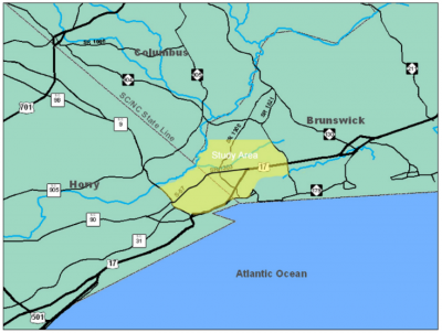
The idea to lengthen Carolina Bays Parkway from S.C. 9 in Horry County across state lines through to U.S. 17 in Brunswick County has lingered for more than a decade. Now that North Carolina has the funds to move forward with a project development study, the bypass extension is back on the map.
Supporter Spotlight
A 2006 feasibility study conducted by the North Carolina Department of Transportation, or NCDOT, in coordination with its South Carolina counterpart, examined a series of potential corridors for the parkway extension. One of the routes takes the proposed, multi-lane bypass through Caw Caw Swamp, an area that stretches northwest of Shallotte several miles to the Waccamaw River near the South Carolina line.

“It’s a natural drainage area,” said Phil Norris, a resident of the area and former Brunswick County commissioner chairman. “It’s in a pretty extensive watershed and floodplain area. It’s a major watershed in southern Brunswick County. If DOT doesn’t change the alternatives through that area, the design would have to accommodate building above the flood plain area.”
Norris, who lives in the Hickmans Crossroads community of Calabash, said he fears that building a road through the area would destroy wetlands and affect the flood plain.
Brunswick County officials are in the midst of trying to implement flood mitigation measures in the Caw Caw area. County commissioners earlier this year were presented with a series of possible flood control options, the costs of which ranged from $1.5 million to upwards of $30 million.
Norris said he hopes the problems the county is facing will prompt transportation officials to stay clear of building the parkway extension through the area.
Supporter Spotlight
“The alternatives that would stay on higher ground I would hope would be more cost effective and would not have as much of an impact on the wetlands,” he said.
Jay McInnis, NCDOT project engineer, said the possible corridors mapped out in the 2006 study are “very preliminary.”

“These alternatives, people might never see them again,” he said. “Those alternative areas are going to be a starting point. People should be mindful that the project is going along, but they shouldn’t be worried about those lines because they could change. They were the best look at the time, but we’re taking a more detailed look now. We’re going to have a large study area we’re looking at. We understand that this is an area with a lot of wetlands so that is certainly something that we’ll be mindful of and that will play into our development of alternatives.”
This summer the department contracted a team of engineering firms led by Raleigh-based CALYX Engineers and Consultants to develop the project and complete environmental studies.
Funding for the multi-million-dollar project is still in the early stages. There is no money yet for construction and right-of-way acquisition.
“South Carolina doesn’t yet have funding, but there’s a bond referendum in Horry County that would go toward roads and some of the money, if that bond passes, would go toward the parkway,” McInnis said.
The project study will help determine specifics such as how many lanes the expressway will have and a speed limit.
The average length of the Brunswick County portion of the parkway, based on alternatives in the 2006 feasibility study, is about nine miles. The total estimated length of the extension is roughly 14 miles.
“A part of what we’re doing right now is gathering information to help establish the purpose and need,” McInnis said. “Generally, what we see is the need to divert some of the traffic off (U.S.) 17 in both Brunswick and Horry counties.”
The next step, McInnis said, will be getting the public’s input.
The project team is expected to accept public input on the proposed project by year’s end, according to NCDOT’s website.
“We’ll be getting that information plus we’ll be getting traffic data, looking at accident data, looking at how big of an area we’ll need to be studying,” McInnis said.
Once the team has an updated set of alternative corridors those will be presented in public meetings in both states.
The project, from start to finish, may be nearly another decade in the making.
“When the draft [environmental impact statement] comes out we’re still only halfway through our process,” McInnis said. “Our schedule right now is that the draft EIS would come out in early 2020 and, following that DEIS, we would have a public hearing and, at that public hearing, we would have the selected alternatives.”
A final EIS may be released in the fall of 2021, with a record of decision coming out sometime around the spring of 2022.
According to information provided on NCDOT’s website, the project will cost an estimated $202 million to $280 million.


