Reprinted from the Island Free Press
RODANTHE — The proposed bridge project in Rodanthe is a good example of the difficulty that government has trying to make everyone happy.
Supporter Spotlight
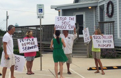
Holding signs and chanting “Save our Sounds,” a small group of northern Rodanthe property owners gathered in front of the Rodanthe-Waves-Salvo Community Building on Hatteras Island last week to protest the project that they say will ruin kiteboarding off their Pamlico Sound beach and hurt property values, livelihoods and lifestyles in their neighborhood.
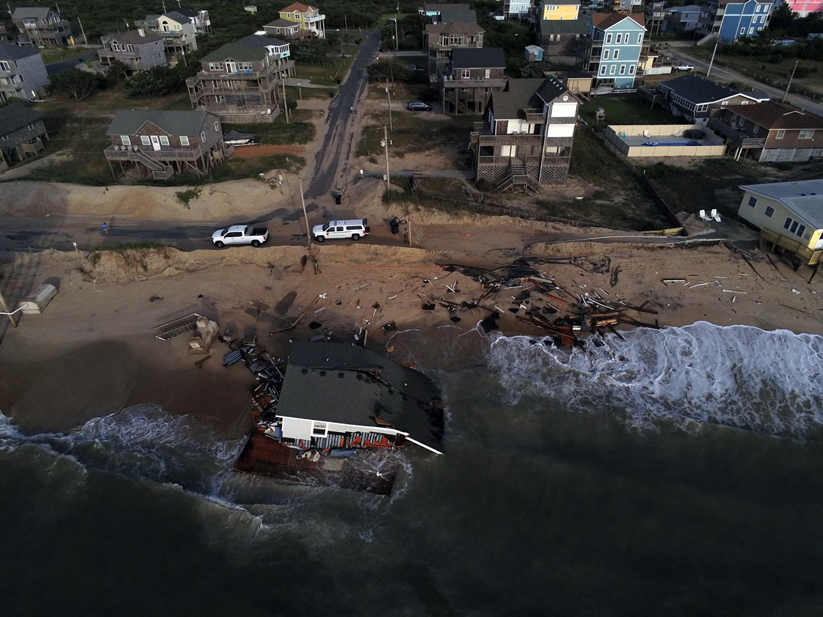
Inside, officials with the state Department of Transportation were conducting the second of three public hearings on the Outer Banks to consider the revised environmental assessment on the bridge. The project proposes a long-term solution to keeping the road open through Mirlo Beach, an area subject to increasingly frequent overwash and road closures.
Supporter Spotlight
And many long-time residents seem relieved that something is finally going to be done to keep traffic flowing on N.C. 12, the main road on Hatteras Island.
“Most of the folks have been interested, but not unhappy,” Brian Yamamoto, NCDOT project development engineer, summing up the feedback he had heard at the hearing., which was attended by more than 90 people. Other hearings were held in Ocracoke and Manteo.
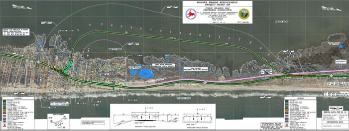
The preferred alternative is a 2.4-mile “jug handle” bridge between the south end of Pea Island National Wildlife Refuge and the north end of Rodanthe.
But in order to do that, Midgett’s campground, three businesses, and two homes would have to be removed, and other properties, while not having to be moved, would suddenly have an intrusive strip of asphalt as their neighbor.
In that light, the frustration expressed by protesters is understandable, said Malcolm Fearing, a Manteo native who represents DOT’s Division 1 on the state Board of Transportation.
“I get it,” Fearing said, in between chats with residents and local officials at the meeting. “That’s the tough thing about transportation projects – they affect people. This is one of those things. It’s a tough call.”
But others view the Rodanthe bridge as a necessity, a compromise borne out of years of grappling with how to keep one of the most vulnerable sections of road on the Outer Banks passable and safe for residents and millions of tourists who visit the island every year.
“There’s no easy answer,” said Scott Caldwell, who along with his wife, Martha Midgett Caldwell, owns about 20 acres and numerous businesses in Rodanthe. “In order to survive down here as a business owner, you have to have that road open. I just feel like what they’re talking about, this is the best scenario – and I stand to lose the most from this.”
An earlier alternative that DOT had considered would have included exit ramps that would have “wiped out” Island Convenience, the family’s very busy store on the north end of Rodanthe, Caldwell said. The current proposal would eliminate the 23-site Midgett Campground, an 8-year-old business that is highly productive, he said. It would also take the family’s two residential structures, a building that houses four businesses – a food pantry, a bake shop, thrift store and an arcade – and just north of that, the Whaley Jack Burger Shack.
“Martha’s parents worked their tails off to get that property,” he said.
Martha Caldwell’s father was the late Mac Midgett, a businessman and county commissioner who had been one of the most distinctive characters in Dare County during his lifetime.
Caldwell said he has known that the DOT plan has been in the works since Hurricane Irene in 2011. But considering the options, he said that he knows also that there’s no way to stop it. He plans to hire an attorney to assist in negotiations with DOT.
“If I can get just compensation, I’m good with it,” Caldwell said. “We have been through all this different stuff and we’re at the edge of getting it done. It’s hard to please everybody, but you know long-term, we’ve got to have this bridge.
“If that road is not done,” he said, “we’re done.”
The proposed bridge bypasses a hot-spot just north of Rodanthe – called “S-turns” by surfers and “S-curves” by coastal engineers – renowned for great waves and a huge annual erosion rate, respectively. When Hurricane Irene struck the Outer Banks in August 2011, a section of Highway 12 between S-curves and Mirlo Beach was breached, as well as a section of road a little further north in Pea Island.

Over the last 15 or so years, various fixes at Mirlo were discussed and studied, including beach nourishment and different versions of bridging. Along the way, the project was grouped in with a lawsuit challenging the Bonner Bridge replacement project, leaving the long-term solution for both breaches tangled in with the legal fate of the bridge project.
The lawsuit was finally settled, and the Bonner project has begun. An emergency beach nourishment project was done in 2014 at S-curves to protect the road while road planners worked on the Rodanthe solution. An interim concrete bridge is currently being constructed at the Pea Island breach.
Brian Yamamoto, NCDOT project development engineer, said that the preferred Rodanthe alternative was decided officially a few months ago. But he said an early concept emerged about 15 months ago, after officials with the U.S Fish and Wildlife Service and NOAA Fisheries expressed concerns about the effects on underwater grasses with an alternative that curved farther west into the sound. In the revised plan, the bridge now comes in closer to land but affects less grasses.
The preferred alternative in 2014, a bridge within the existing easement of N.C. 12, was dropped because of its exposure to the ocean.
If the project, estimated to cost about $200 million, moves forward as planned, Yamamoto said, it can be awarded to a contractor as early as this fall. After gearing up for about another year, it would take an additional three years to complete.
Warren Martin, who owns property off Corbina Drive, said he and a group of about 20 neighbors in northern Rodanthe prefer another alternative such as a causeway.
“We realize that there’s a need to have a safe corridor,” Martin said.
The opponents explain their late-to-the-party objections as being blindsided by the latest change in the plan that brings the bridge much closer to the shoreline.
“What upsets us is it seems like a lot of this stuff was done from behind closed doors,” said Guy Finn, another northern Rodanthe property owner.
Rick Shaftan, who recently created a video against the proposal, favors moving the road away from the shoreline and bridging at Mirlo Beach.
“This is ridiculous,” he said, pointing towards the wall, where a map of the proposed plan showed the bridge curving right into the area around Corbina Road.
“This is a show,” he said about the hearing.
Mark Haines, who owns property on Pappy Lane and operates a soundfront kiteboarding business, said that the DOT needs to re-consider the severe effects to residents and businesses.
He said he favors having the bridge further out in the sound, where it would not hinder kiteboarding as much, or better still, have the roadway come in north of Rodanthe or move the roadway to the west. Haines said that no kiteboarder is going to want to rent one of his houses while all the work is being done. And the bridge itself would hurt his business overall because its structure alters the wind quality and creates an obstructive hazard to the boarders.
“I get a pit in my stomach here just listening to these guys,” Haines said. “They say it’s a public hearing, but they’ve already decided what they’re going to do.”
In responding to a question about a possible lawsuit, Haines said the opponents “are leaving all options on the table.”
“At the end of the day, we just want to feel part of the decision,” he said.
When asked whether the preferred alternative could be changed at this stage of the process, Yamamoto, with DOT, said “it’s possible. But with such a long history with working with the public and the agencies, we’re almost out of different things to try. And we have tried a lot of different things.”
Altering the plan would be “difficult,” he said, requiring each stakeholder agency to be contacted again. If the option ended up being changed, most likely DOT would have to do another supplemental document, which would require more public meetings and more public comments to consider – probably taking a couple of years to complete.
Even if it was an option DOT had already looked at, he said, there would still be the necessity of going back to consult with all the agencies, although the supplemental document would not have to be done.
This story is provided courtesy of the Island Free Press, a digital newspaper covering Hatteras and Ocracoke islands. Coastal Review Online is partnering with the Free Press to provide readers with more environmental and lifestyle stories of interest along our coast. You can read other stories about Hatteras and Ocracoke here.


