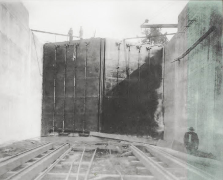
RIEGLEWOOD — Fifteen feet above the water and perched on a two-foot wide gate, Ranger Tom Charles swiftly spins one of eight wheels that raise and lower the butterfly valves that help to regulate water flow at Cape Fear Lock and Dam No. 1. “It is still a manual operation,” he smiles. “Just like when the lock was built.”
Fortunately for Charles and the other lockmasters, opening and closing of the gates is now automated. “Before, the lockmaster had to use a large key that acted like an Allen wrench to manually work the gates.” The automation cut the time nearly in half for locking a vessel through.
The 200-mile-long, murky and mysterious Cape Fear River finds its start at the confluence of the Deep and Haw Rivers in Chatham County, just below the Jordan Lake Dam. From there, the river meanders slowly through the sandhills to the coast through Fayetteville down to Wilmington.
In the early days of Colonial America, the river was the major transportation route to the interior from the coast. Today, the river is only navigable from Wilmington to Fayetteville, thanks to the three locks and dams that provide a deep channel for boat traffic.
Before the first lock and dam was built by the U.S. War Department in 1915, only shallow drift paddlewheel vessels could make their way upriver and down, while large, flat–bottom barges and rafts carried goods downstream from Fayetteville.
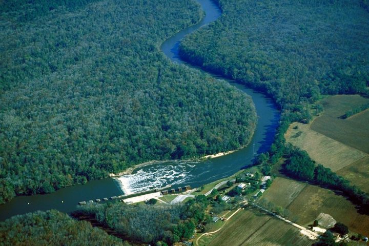
Lock and Dam No. 1 is on a curve at King’s Bluff in Bladen County, a few miles west of East Arcadia and Riegelwood and 43 nautical miles north of Wilmington. Construction began in 1911 and was completed in 1915 at a cost of about $2.4 million. The 20-foot wide and 200-foot long lock structure included an eight-foot lift, which was increased to 11 feet in 1934, with the first of only three major renovations.
Supporter Spotlight

A total of three locks and dams were built and are operated by the Army Corps of Engineers. All are in Bladen County. Lock and Dam No. 2 at Browns Landing in Elizabethtown was built in 1917, and the William O. Huske Lock and Dam completed in 1935 are at Tolar’s Landing, just south of the Cumberland County line.
Each lock and dam included two lockmaster homes. The lockmasters and their families lived on site, manning and maintaining the locks. Today, only one house remains at each location. The 100-year-old white clapboard house at Lock and Dam No. 1 is used for offices and a small environmental education center.
In the early years of the navigation structures, traffic on the river averaged close to 500,000 tons annually and included mostly barges hauling pulpwood and petroleum products to the coast. The commercial traffic steadily dwindled to a few vessels a year after 1995, but recreational traffic has seen an increase since then.
“Boaters can put in at Fayetteville at sunrise and be down to Carolina Beach by sunset,” said Charles, a park ranger for all three locations. “These locks still make the river navigable from Fayetteville to the coast, just like they were intended for 100 years ago.”

Major renovations at Lock and Dam No. 1 were completed in the 1930s and 1960s, but the most recent renovation that drew national recognition was the installation of a “rock arch ridge” in 2013 to serve as a fish passage for the species that move upriver to spawn. A new fishing pier with adjacent parking was also added.
Over the last century populations of many native migratory fish populations in the Cape Fear River, including striped bass, shad, river herring, Atlantic and shortnose sturgeon have declined by as much as 90 percent. Much of this decline was attributed to the loss of spawning habitat caused by the construction of the three large lock and dam facilities.
“The pools above the locks and dams are used for water intake for municipal water supplies downstream, so the dams cannot be destroyed,” Charles said. The rock arch ridge provides a viable solution to returning fisheries to the natural state. The first of its size along the East Coast, the success of the fish passage is being tracked by the N.C. Wildlife Resources Commission.
“Before the ridge, we were manually locking the fish upriver to spawn,” Charles said. “We would open the lower gate, attract the fish in, and lift them.” This manual operation lasted from March to May during the traditional fish spawning season. Now, the fish migrate naturally upriver through the rock arch ridge, which includes pooling areas for the fish to rest during the trip.
The Cape Fear River Watch has partnered with the Corps of Engineers in a formal cooperative agreement since 2013. Kay Lynn Plummer-Hernandez is a wildlife biologist and serves as the education coordinator for the nonprofit Cape Fear River Watch. “With the construction of the rock arch rapids complete, we advocate for fish passage at Lock and Dams 2 and 3 in order for anadromous fish, including the striped bass, to reach their original spawning grounds.”
Another recent addition to the King’s Bluff facility is an interpretive boardwalk along the river just north of the lock. The elevated boardwalk allows visitors to walk into a bottomland hardwood forest that serves many critical roles in the habitat and ecology of the lower Cape Fear River Basin.
The boardwalk was funded with the assistance of International Paper Co., which operates the nearby Riegelwood Mill, and the U.S. Fish and Wildlife Service, and included creation of a large rain garden at the center of the newly constructed parking lot near the river.
“Interpretive signs will be placed along the boardwalk shortly, and that will complete a plan enabling groups to experience one-hour tours of the rock arch rapids, the rain garden and the boardwalk, with an option to have tours led by Cape Fear River Watch,” Plummer-Hernandez said.


