EAST LAKE — While many people rejoiced that the proposed Mid-Currituck Bridge was included in North Carolina’s draft 10-year transportation plan, not much griping has been heard about the U.S. 64 project being left out.
But some are worried that the 55-year old bridge over Alligator River, which is part of the now unfunded U.S. 64 road project, will continue to deteriorate.
Supporter Spotlight
“That bridge should be looked at as a separate project,” said David Clegg, the Tyrrell County manager.
Built in 1960, the 2.8-mile Lindsay C. Warren Bridge is a swing span that opens as much as 35 times a day for marine traffic. It is considered structurally deficient but safe to cross.
At one time, there were 19 mix-and-match alternatives in a plan to widen the highway to four lanes through miles of swampland in Alligator River National Wildlife Refuge and the small communities of Alligator in Tyrrell County and East Lake in Dare County. Miraculously, a suitable alternative was finally found.
But now, construction plans for the proposed 27.3-mile project – the last section of U.S 64 to be widened from Raleigh to the coast — are on hold.
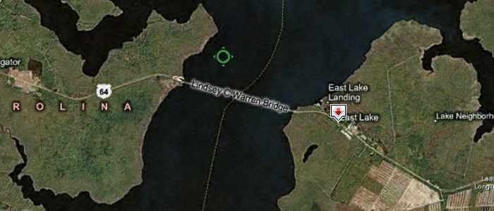
Stretching between Columbia and Manns Harbor, divided in half between Tyrrell and Dare counties, the proposed project is estimated to cost $392 million. Unless the funds are allotted in the transportation plan, the project will not move forward.
Supporter Spotlight
With residents and environmentalists angry about the proposed project for the much of the 18 years or so it has been in the planning stages, the lack of outrage at its omission in the state plan is not surprising.
“We’re fine with them doing it when the funding is available,” said Rosemarie Doshier, a resident of East Lake. “We’re in no rush to get it done.”
In fact, until about 1½ years ago, residents had fought the initial proposal that had the highway cutting right through their community, taking out 12 homes, churches and historic cemeteries and the 1936 fire tower.
Environmental groups, including the N.C. Coastal Federation, question the need for the project, citing environmental damage to the refuge and overall lack of traffic on the existing two-lane highway. In response, the state said that U.S. 64 is important as a hurricane evacuation route, and that the bridge over Alligator River is overdue for replacement.
An unusual compromise was announced in August 2013. The refuge managers had agreed to allow the road to curve into its land in order to bypass East Lake. Meanwhile, on the Tyrrell County side of the project, four of the five residents affected in Alligator told the N.C. Department of Transportation, or DOT, that they were willing to sell their often-flooded property.
Despite that the major conflict over placement of the road had been resolved, the U.S 64 project did not meet the state’s new prioritization formula for transportation projects, which in part is based on traffic congestion and population. Still, the State Transportation Improvement Program, or STIP, that was released in December is a draft that will go through a public comment process. And that means there will be changes.
“It’s not final,” said Ted Devens, DOT project manager. “There’s been a lot of push back from rural parts of the state.”
Devens said that all the major stakeholders in the project have agreed on how to proceed, and the final Environmental Impact Statement, which documents the decisions made throughout the planning process, is nearing completion.
“This thing has been studied since 1998. So we’ve made all this progress,” he said. “We have completed all the merger team coordination, and we have a concurrence.”
Devens said that the U.S. Fish and Wildlife Service was enthusiastic about how the road design made allowances for the different creatures that routinely cross the highway within the 154,000-acre refuge, ranging from bears and wolves to snakes and rodents. The refuge managers agreed that a loss of some of their land in East Lake was a worthy trade-off.
“The team agreed that the benefits of the wildlife crossings to the whole region justified the taking,” he said.
So far, consultant work for the project has cost $4.2 million, Devens said. That figure does not include costs for DOT time, he added.
Skip ahead to 30 seconds to take a road trip over the Lindsay C. Warren Bridge that crosses Alligator River. We hope you don’t mind 80s rock.
Devens said that public meetings will be held in March and April to discuss the draft STIP. It will be known by June, when the STIP is finalized, whether or not the U.S. 64 project has been added to the 10-year plan.
Even if the state decides for the time being to not widen U.S. 64, it must address the aging bridge, said Clegg.
In a resolution passed on Dec. 2, the Tyrrell County Board of Commissioners said that the two-lane bridge is “outdated, narrow and unsafe” and does not meet current state and federal safety standards.
The board requested that “without delay” the state “design, schedule, fund and construct” a new bridge.
“We didn’t want DOT to think that we looked at that project all having to be done simultaneously,” Clegg said, “because we don’t.”
Clegg said that the region and Tyrrell, among the poorest regions in the state, are losing out in the new transportation formula that favors factors such as urban congestion. Neighboring counties of Dare, Hyde, Washington agree, he said. “We all live and die by Highway 64,” Clegg said.
“If you look at that process, northeastern North Carolina is not garnering enough points to really have anything put on the drawing board anytime soon,” he said. “I think if you look at general improvements, we came out at the short end of the stick.”
Even the proposed Mid-Currituck Bridge — one of the northeast’s major projects in the draft STIP — that would alleviate traffic to the Outer Banks from Virginia is not scheduled to start the permitting and acquisition phase until 2019.
Clegg said that the Alligator River bridge should be viewed in light of its importance to the people who depend on it as their only route to jobs and nearby communities, as well as for the tourists coming from the west. For instance, repair of the swing span gears in 2013 resulted in a 90-minute detour for travelers.
“I don’t think a lot of these traffic counts are necessarily reflecting tourism traffic,” he said.
The most recent bridge inspection in 2014 gave the bridge a “sufficiency” rating of two out of 100, Devens said. “That does not mean the bridge is unsafe,” he explained in an email. “It means that, after studying a number of factors including bridge inspection results, traffic volumes and road widths, engineers used a standard formula to rate the bridge’s ability to remain in service. Based on those calculations, they consider the bridge ‘structurally deficient’ and in need of replacement. A low rating places a higher priority on bridge replacement.”
Devens said that the likelihood of building the bridge as the first phase of the project – followed by the Tyrrell section, then the Dare section – has always been the case.
“This discussion of separating the bridge out is nothing new,” he said. “In fact, that’s right in character with the project all along.”
In 2013, costs for the bridge and connectors to both sides were estimated at $210 million; the Tyrrell portion of U.S. 64 was estimated at $73 million and the Dare side at $110 million.
Devens said that the bridge design is similar to that of the Virginia Dare Memorial Bridge between Manteo and Manns Harbor, except it has wider outside shoulders. The old bridge, he said, is still useable.
“But again, we want to get it replaced before it gets unsafe,” he said.


