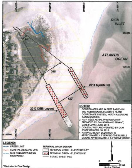
 The Figure Eight Homeowners’ Association now wants to build a terminal groin more than 400 feet farther north than originally proposed. Graphic: Figure Eight Homeowners’ Association |
FIGURE EIGHT ISLAND — A new location for a proposed terminal groin at the north end of Figure Eight Island will be included in the U.S. Army Corps of Engineers’ final environmental impact study to be released later this year.
In an effort to appease north-end property owners, the preferred spot for a terminal groin is about 420 feet farther north of the one included in the Corps’ 2012 draft environmental study.
Supporter Spotlight
The groin is also 100 feet shorter and will cross about 300 feet of coastal wetlands, according to an April 23 newsletter distributed to the private island’s property owners.
Terminal groins are long, low walls built perpendicular to shore at inlets. They are designed to reduce shoreline erosion by trapping drifting sand.
Despite beach re-nourishment efforts, chronic erosion on the island’s north end prompted Figure Eight landowners to search for alternatives.
The Figure 8 Island Homeowners Association has been working on developing a long-term management plan for Rich Inlet to protect the north end of the private island. Coastal Planning and Engineering of North Carolina is developing the Rich Inlet Environmental Impact Statement under the Corps’ supervision.
Several of homeowners on the island’s north end asked the association to consider pushing the proposed terminal groin farther seaward to keep it off of their property.
Supporter Spotlight
Some of them have been steadfast in their refusal to grant the association the easements it would need to build a wall. Unlike a municipality or other government body, the homeowners’ group does not have the authority to condemn and take land.
“We are telling people we tried to listen to the various inputs and this is where we are proposing it to be,” said Frank Gorham, the association president and also chairman of the state’s Coastal Resources Commission, “This is just our submittal. We do not know what the Corps will do.”
The Corps’ final EIS, which will be released in the next three to six months, will include the new location, Mickey Sugg, project manager with the agency’s Wilmington office, confirmed last week.
“Upon our evaluation of their new location, our office determined the new location was a minor variation of the existing terminal groin alternatives and within the spectrum of the existing alternatives discussed in the draft EIS,” Sugg wrote in an email. “The new location alternatives are not considered ‘new’ in the sense that our regulatory office will have to develop a supplemental EIS prior to release of the final EIS.”
Public comments will be accepted once the final study is released. If the homeowners’ association applies for a permit to build the groin, a public notice will be issued for comments, Sugg wrote.
 Frank Gorham |
 Derb Carter |
Gorham said the association will determine an estimated cost of the proposed project after the Corps releases the study. Property owners must approve the project before the association applies for a permit, he said.
“Once we know the costs, we will schedule extensive informational briefings for homeowners,” Gorham wrote in the newsletter. “The board will then submit a proposed project and corresponding assessment to the full membership. You, the membership, will decide if we proceed with the proposed project.”
Opponents of the proposed terminal groin argue the associationshould have obtained permission from all of the north-end property owners before moving forward with an EIS.
In July 2012, Derb Carter Jr., the senior attorney and director of the North Carolina office of the Southern Environmental Law Center, wrote the Corps stating that the homeowners’ group had to first demonstrate it has the necessary property rights to build.
“The HOA is the applicant for this project even though they don’t even have HOA approval yet,” Carter said in a telephone interview. “It’s not that the project is close their property, it’s on their property. They don’t have legal permission or the ability to force those homeowners to build a terminal groin on their property. This new location has nothing to do with engineering or environmental impacts. It’s about getting away from the properties and thinking that if they push it further out it would be more acceptable.”
Carter, whose mother-in-law owns a home on the island, said lots on Figure Eight were platted to go to the mean high water mark.
That means that, unless a groin is built off shore, portions of it will be on private property, he said.
He also argues that the corps should allow a public review process of the new alternative and the only way to do that is to issue another draft EIS.
Todd Miller, the head of the N.C. Coastal Federation, last fall urged to the Corps to restart the EIS process upon learning the homeowners’ association was discussing a design and location for a terminal groin not included in the alternatives reviewed in the 2012 study.
He said the corps needs to take into consideration the fact that the draft environmental study is based on aerial photographs of the island from April 2006. Pictures taken in June 2012 show that about 350 feet of new wet sand beach has accumulated in the same area.
The new alternative includes a groin that would span 1,500 feet, beach fill along the ocean shoreline that would extend south about 4,500 feet from the groin and beach fill along 1,400 feet of the Nixon Channel shoreline.
The proposed groin would cross about 300 feet of coastal wetlands on the north end of the island, reducing the footprint by more than 300 feet from the initial preferred alternative.
Moving a groin further north from the new proposed site “would likely have a negative impact and would result in greater environmental concerns,” according to the association newsletter.
Figure Eight Island is one of four beach communities currently planning to build terminal groins since the N.C. General Assembly in 2010 legalized up to four such structures. The others are Holden Beach, Ocean Isle Beach and Bald Head Island in Brunswick County. All are in various stages of the environmental review process required by federal law.
Bald Head Island voters will decide today whether to approve an $18 million bond referendum to fund their proposed groin. Voters across Brunswick County are also being asked today to bump the sales tax by 25 cents, giving county commissioners the authority to raise the rate from 6.75 cents to 7 cents on the dollar, an estimated $3 million in additional revenue that would be split equally between school capital projects and beach projects, including terminal groins.
Figure Eight’s proposed project would be privately funded. If property owners there approve the terminal groin, the homeowners’ association will have to apply for a Coastal Area Management Act major permit. If the state denies the permit, the HOA could ask for a variance, a process that would go before the CRC.
Gorham said if that happens, he would recuse himself as CRC chairman.


