FIGURE EIGHT ISLAND — A new design and location for a proposed terminal groin at the north end of Figure Eight Island are “significantly” different from alternatives reviewed in a 2012 environmental study, according to the head of the N.C. Coastal Federation.
The latest changes – a longer, bigger structure further seaward – are so different that the U.S. Army Corps of Engineers should restart the environmental impact study process, said the federation’s Executive Director Todd Miller.
Supporter Spotlight
“Design differences are so drastic that the new design cannot be considered a version of the previously proposed preferred alternative, but rather a completely new alternative,” Miller wrote in a Sept. 6 letter to Mickey Sugg, project manager with the corps’ Wilmington office.
The Figure Eight 8 Homeowner Association’s latest proposal has a new, angled footprint and would further affect the natural habitat, barrier island processes and public trust rights, Miller wrote.
The Corps has not received the engineering report on the new proposed location, Sugg wrote in an email responding to questions.
“If Figure 8 chooses this as the ‘applicant’s preferred alternative,’ our office will review whether the new location is a variance of the existing preferred alternative or whether a supplement to the DEIS (draft environmental impact statement) will have to be developed,” he stated.
Terminal groins are long, low walls built perpendicular to shore at inlets. They are designed to reduce shoreline erosion by trapping drifting sand.
Despite beach re-nourishment efforts, chronic erosion on the island’s north end prompted Figure Eight stakeholders to search for alternatives.
Supporter Spotlight
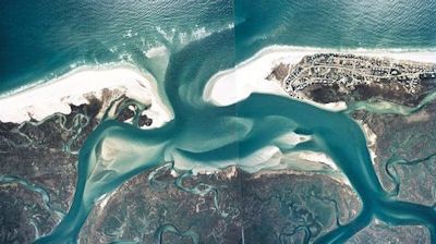 Opponent of a terminal groin on Figure Eight Island, right, fear the groin will affect the extensive shoals of Rich Inlet. Photo: Army Corps of Engineers |
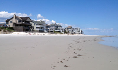 Sandbags protect some of the houses on the north end of the island. |
The association has been working on developing a long-term management plan of Rich Inlet to protect the north end of the private island. Coastal Planning and Engineering of North Carolina is developing the Rich Inlet Environmental Impact Statement under the corps’ supervision.
The federation learned about the proposed alternative from the official minutes of the homeowner association’s July board meeting, which was held well after the public comment period ended for the corps’ DEIS.
Opponents who voiced their objections to a terminal groin being built at the north end expressed concern about the negative effects a wall will have on Rich Inlet.
Some of the property owners whose land is on the north end of the island have been steadfast in their refusal to grant the association the easements it would need to build a wall.
Following several meetings with property owners whose land is near the proposed site, the association got the corps’ permission to include a proposal for a possible alternative site.
The new alternative does not solve that matter, Miller wrote.
“The only reason that the new alternative has emerged at this late date in the DEIS process is an attempt by the Association to bypass the private property rights of individuals who have refused to grant easements to allow the groin to be built on their land,” he stated. “The Association does not have the power to condemn their properties to construct the project.”
David Kellam, administrator of Figure Eight Island, did not return calls seeking comment.
Figure Eight Island is one of four beach communities currently planning to build terminal groins since the N.C. General Assembly in 2010 legalized up to four such structures. The others are Holden Beach, Ocean Isle Beach and Bald Head Island. All are in varying stages of the environmental review required by federal law. The Corps is conducting those reviews.
The Figure Eight association and its technical consultants, “believe that installing a terminal groin is conceptually the preferred option to provide protection to the north end of the island,” according to the minutes of the association’s July meeting.
The DEIS lists four shoreline management alternatives, the first of which is that the association continue pumping sand dredged from the Nixon Channel area of Rich Inlet onto the northern end of the island.
Other alternatives include taking no action, relocating the ebb channel within the inlet and maintaining its new location or building a terminal groin.
Proponents of the last alternative argue that groins do not worsen erosion on nearby beaches by starving them of sand and would be more cost effective because a wall would reduce the frequency of dredging Rich Inlet.
Terminal groins, they say, have proved successful at other inlets along the coast – the Fort Macon groin at Bogue Inlet and the Pea Island groin at Oregon Inlet.
Opponents say a terminal groin could compromise public access to Rich Inlet, hasten erosion by interfering with normal sand flow long the beach and be expensive to build and maintain.
Should the corps issue a supplement to the DEIS, it “will be no small or inexpensive undertaking,” Miller said.
That’s because the corps’ review was based on structures that were sandbagged at the time of the study.
“These structures are no longer imminently threatened since the beach has now naturally accreted,” Miller wrote. “This change in circumstances should require a redetermination of purpose and need for the project.”
The corps also should take into consideration the fact that the DEIS is based on aerial photographs of the island from April 2006. Pictures taken in June 2012 show that about 350 feet of new wet sand beach has accumulated in the same area.
Sugg stated that the corps’ next step in the evaluation process will depend on whether the new location is a variance of the existing alternative or a supplement to the DEIS.
The DEIS process should be stopped, Miller stated, and a new process will “have to be developed starting at step one.”


