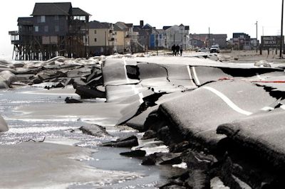
 N.C. 12 north of Rodanthe looked like a crazy amusement park ride after Hurricane Sandy went by. Photo: NCDOT. |
The story was compiled from previously published stories in the Outer Banks Voice and the Island Free Press, two online newspapers on the Outer Banks.
Supporter Spotlight
RODANTHE — It’s been more than a month since Hurricane Sandy passed hundreds of miles off the N.C. coast, but state transportation officials are still struggling to keep a passable road open on Hatteras Island on the Outer Banks.
When it went by on Oct. 28-29, Sandy flushed away protective dunes and sandbags and broke up about a half-mile of pavement on N.C. 12 at an area known as the S-curves near this island community. It’s a notorious trouble spot of frequent flooding on Hatteras Island’s only road to the mainland.
The aftermath was different this time. “Much of our right of way is now in ocean,” an engineer for the state Department of Transportation said when the skies cleared… briefly.
Two nor’easters and generally foul weather after Sandy merely made a bad situation much worse. Hastily thrown up sand berms were flattened and the ocean washed over the buckled pavement with each high tide.
With nowhere to put a new section of road, DOT carved out and staked a temporary, rough sand path alongside the battered pavement. It opened to four-wheel drive vehicles only on Nov. 21.
Supporter Spotlight
A few old-timers may have remembered the days when sand roads were the only routes on Hatteras Island and may have boasted that they got along just fine without fancy SUVs.
The drivers of those modern SUVs, however, weren’t faring as well. They were getting stuck. Routinely. DOT reported on its Facebook page that 45 vehicles had to be towed on one Sunday.
After the ocean stopped regularly overwashing the route at high tide, the sand dried out and became soft and churned up, making the tire ruts deeper. Since the route is just a set of tire tracks in each direction, stuck vehicles hold up traffic in both directions.
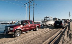 |
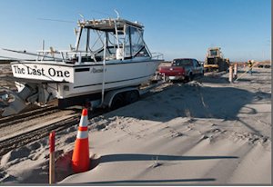 Traffic, top, slowly makes its way along the sand route that bypasses bucked N.C. 12 in Rodanthe. Some vehicles towing boats got stuck, bottom, before state officials banned towed vehicles on the road. Photos: Don Bowers, Island Free Press. |
In response, DOT officials put more restrictions on the route: No trucks weighing more than a ton – about the size of a Ford F350 or a Chevrolet/Dodge 3500 – and no vehicles towing trailers.
Dare County Sheriff’s deputies at two checkpoints along the road enforce the restrictions.
The four-wheel-drive route is open from 5 a.m. until 10 p.m., but before dawn and after dusk, the Sheriff’s Office is providing a pilot car that leads traffic between Rodanthe to the Bonner Bridge.
As DOT struggles to keep the route passable, a decision on the long-term fix at the troublesome spot has been put off until late winter — more than a year later than originally expected.
Beth Smyre, a DOT project manager, said that with the challenges created by Sandy, the focus on a permanent solution has been at Pea Island, where a temporary bridge was built last year over a new inlet cut by Hurricane Irene last year.
The merger team —representatives of state and federal agencies —in early November officially signed off on building the replacement bridge in Pea Island within the existing easement, basically where the temporary bridge is situated, Smyre said.
“We’re trying to get the documentation done so we can award a contract,” she said.
After the contract is done for the 2.1-mile-long concrete bridge, hopefully in March, Smyre said, the department will announce the chosen alternative for the northern Rodanthe breach.
Alternative fixes for the road at the S-curves were narrowed down by DOT to two possibilities after a series of meetings last year. One proposed long-term solution would be to build a 2.5-mile-long bridge that would be 25-to 30-feet high and would go out into Pamlico Sound around the S-curves and tie into the highway south of Mirlo. The other alternative would be to build a bridge within the existing right-of-way.
Initially, the selection was supposed to be made in late 2011. The next preliminary deadline in spring 2012 came and went without a decision. All progress was halted when Hurricane Sandy blew through, and problems were exacerbated by the two northeasters that followed.
Smyre said that the driving surface of the Pea Island bridge will be 23 feet high and cost just under $100 million. Construction is expected to take about two to three years, and traffic will be maintained on the temporary bridge until the replacement is completed.
“The new bridge is going to be within the easement,” she said. “The impact to the environment is really low.”
 Bobby Outten |
 Allen Burrus |
An environmental assessment providing details about the bridge will be issued for public review within weeks, she said, followed by a 30-day comment period and public meetings. The same will be done in the near future for the two alternatives at Rodanthe.
After the public process is complete on each project, she said, a final document will be issued for each one that provides details on the chosen alternative.
Meanwhile, Dare County is exploring the potential of doing beach nourishment at Rodanthe as part of the long-term solution, separate from DOT. The transportation department had dropped plans last year to consider pumping sand on the beach, citing high costs and lack of available sand.
But county manager Bobby Outten said the discussion by the Dare County Board of Commissioners is at such an early stage, it’s not even known whether the National Park Service would challenge the county’s right to nourish at Mirlo, where the Park Service beach appears to have eroded away long ago.
Allen Burrus, a Dare County commissioner, said last week that high-level officials at DOT told him a deal has been worked out with the Army Corps of Engineers to place sand on the beach in front of the troubled S-curves.
According to Burrus, the Corps will receive money from the Federal Highway Administration. A large Army Corps dredge from Wilmington will be brought off Hatteras Island to pump sand onto the beach.
Burrus said details such as how much sand will be placed and where the sand will come from have yet to be worked out. He said Dare County commissioners are hoping the Corps will not only place sand on the beach from the S-curves south into Rodanthe itself, but also build a new dune line along the same route.
It is not known yet how much the project will cost.
The bottom line for Dare County is that access must be maintained for the long term to Hatteras Island, Outten said.
“There are lots of rationales for it,” Outten said, defending criticism of the costs. “We are a donor county — we take in more tax revenue than we take from the state. We’ve got a population down there that we need to supply. We have a national park that needs to have access.”
Outten said it’s hard to imagine the state abandoning a road elsewhere in North Carolina that provides the only transportation route for 5,000 people and millions of tourists that the economy is dependent on.
“In other metropolitan areas, they spend $200 million for a road so people don’t have to sit in traffic,” he said. “We’re not talking about convenience. We’re talking about survival.”
Dennis Stewart, biologist with Pea Island National Wildlife Refuge, said that the refuge is working closely with the DOT and supports both their short-term and long-term efforts to restore access.
But Stewart said the refuge is also waiting to learn what long-term alternative the DOT will choose in Rodanthe. There’s no issue whatsoever if they build a bridge in the existing right-of-way, he said, but there could be concerns if the option chosen is the one that swings out over Pamlico Sound.
“We’re in a holding pattern until they send us the appropriate information,” he said.
Whether it’s for short-term or long -term purposes, Stewart said that any nourishment at Mirlo, which would include some refuge land, could be problematic if the sand was not compatible. He said he is skeptical that there is enough good sand available to nourish, but he said the refuge will not oppose nourishment outright.
“We have standards that have to be met to put sand on the refuge,” he said.

