*Editor’s note: this story was completed prior to Hurricane Sandy’s arrival on the East Coast. Once again the Outer Banks experienced transport disruption and flooding. Our thoughts are with everyone in North Carolina and up the coast affected by the storm.
North Carolina’s Outer Banks – that string of narrow islands that wrap a protective barrier between the Atlantic Ocean and the mainland’s inner coast – is the first line of defense against devastating effects of winds and surging flood waters from hurricanes, nor’easters, and other coastal storms.
Supporter Spotlight
By default, those barrier islands also are on the front line of the effects of climate change and sea level rise.
A recent study by the Natural Resources Defense Council (NRDC) and the Rocky Mountain Climate Organization (RMCO) looks specifically at the threats of climate change to seven national seashores along the Atlantic coast from Cape Cod to Cape Canaveral.
North Carolina’s Cape Hatteras National Seashore and Cape Lookout National Seashore – which together comprise nearly 200 of the state’s 325-mile ocean shoreline – are among the most vulnerable, according to the study titled “Atlantic National Seashores in Peril: The Threats of Climate Disruption.”
Human-caused climate change is the greatest ever threat to Cape Cod (Mass.), Fire Island (N.Y.), Assateague Island (Md.), Cape Hatteras, Cape Lookout, Cumberland Island (Ga.), and Canaveral (Fla.) national seashores, according to the 2012 report.
“Protecting the resources and values of these special places is among the many reasons for acting now to protect our climate,” the report states.
Supporter Spotlight
For the study, the researchers considered seashore temperature records and long-range projections, historical weather patterns, sea-level rise vulnerability, visitor access and economic impacts.
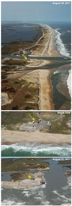
 USGS images of Pea Island over time 2008-2011. |
The seashores are year-round destinations for tourists who enjoy access to miles of undisturbed beaches, history, culture, nature and wildlife. Bird watchers, in particular, are drawn to unique spectacles of colonial and migrating shore birds.
National Park System records for 2010 show that more than 11 million visitors spent more than $5.6 million at all Atlantic Coast national seashores. That includes close to 2.2 million visitors to Cape Hatteras National Seashore and more than a half-million visitors to Cape Lookout National Seashore spending about $150,000 in combined local economies.
Rising temperatures and seas
For the report, the Rocky Mountain Climate Organization researchers compared seashore temperatures from the single decade – 2000-2011– with temperature trends from 1961-1990. They found temperatures rose 1.2 degrees Fahrenheit at Cape Hatteras and 1.8 degrees Fahrenheit at Cape Lookout.
Alarmingly, the heat-up will continue – unless future emissions of heat trapping pollutants can be held to lower levels.
For example, with medium-high future emissions, average temperatures by 2051-2060 could increase by 3 degrees Fahrenheit at Cape Hatteras National Sea Shore; and, by 3.1 degrees Fahrenheit at Cape Lookout National Seashore.
And, by 2081-2090, temperatures could increase as much as 5.4 degrees Fahrenheit at Cape Hatteras, making it “as hot as recent summers in Galveston, Texas”; and by 5.6 degrees Fahrenheit at Cape Lookout, making it “as hot as Fort Meyers, Florida.”
The RMCO study indicates that some computer models project even higher averages for those same decades.
The researchers assert that the future heat-up would negatively impact seashore visitation: When temperatures are in the 100s, the outdoor experience could be a lot less enjoyable.
The study also underscores the vulnerability of these low-lying seashores in the face of rising sea levels.
Rising sea levels are attributed, in part, to the melting of land-based ice, including mountain glaciers and Arctic ice caps. Also, warming sea-surface temperatures make the waters expand and rise.
The researchers looked at a recent U.S. Geological Survey assessment that ranked the relative vulnerability of different portions of the Atlantic coastline based on tidal range, wave height, coastal slope, shoreline change, geomorphology, and historical rate of relative sea-level rise.
As a result, RMCO researchers suggest that Cape Hatteras, Cape Lookout and Assateague Island – with lands that are less than a meter (39.4 inches) above current sea level – are “in a top tier of vulnerability.”
The National Academy of Sciences project that even with lower future emissions, the global average sea-level rise could be about 20 inches by 2100; with higher emissions, 55 inches. (Many coastal scientists say the most likely scenario for North Carolina is at least 29 inches by 2100.)<
“Higher seas especially make a difference in magnifying the effects of coastal storms. With a higher initial sea level, storm surges push farther inland than they did when beginning atop earlier, lower seas,” RMCO researchers say.
Increased risks
The study suggests that human-caused climate change is delivering a one-two punch to the national seashores: rising seas and more frequent and severe coastal storms.
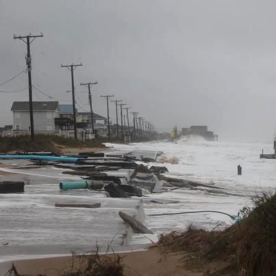
 Hurricane Sandy does damage to Cape Hatteras National Seashore. Photo by Kermit Skinner |
“As a result, the seashores now are being shaped not just by natural forces, but by a new mixture of natural and unnatural forces, which yield different consequences,” the study states.
Visitor access to the national seashores may be at risk in the face of potential loss of roads and bridges.
“In the long term, the current transportation infrastructure may not be adequate, forcing permanent closures of the current roads and their replacement with alternative methods of access,” the study states in general.
The authors single out the repeated and costly efforts to rebuild washed out sections of roads leading to and through Cape Hatteras National Seashore. And, they cite boat and ferry service to Cape Lookout National Seashore as alternative access methods.
An altered climate affects historic and cultural resources, including lighthouses and other physical assets. Already, the National Park Service relocated Cape Hatteras Lighthouse in 1999 at a cost of more than $11 million. Additionally, the historic lightkeeper’s station and Coast Guard Station at Bodie Island Lighthouse, also on Cape Hatteras National Seashore, have been moved out of harm’s way in recent years.
Hotter temperatures, stronger storms and rising seas also pose threats to ecosystems and wildlife, including nesting endangered sea turtles and birds, and the myriad wildlife dependent upon each unique coastal habitat.
Additionally, marine life will most certainly feel the effects of climate change as ocean waters become warmer and more acidic.
Stemming the tide
To stem the tide of threats to national seashores, RMCO researchers and the Natural Resources Defense Council officials say new actions are needed on “an unprecedented scale.”
They call for reducing emissions of climate-changing pollutants, which come mostly from burning fossil fuels. Key steps include:
- Establishing mandatory limits on carbon pollution by at least 20% current levels by 2020 and 80% by 2050;
- Protecting the current Clean Air Act authority of the U.S. Environmental Protection Agency;
- Overcoming barriers to investment in energy efficiency to lower emission-reduction costs; and
- Accelerating development and deployment of emerging technologies to lower long-term emission reduction costs.
Responding to challenges
Change is a constant at national seashores. And planning for change is constant, say Cape Hatteras Acting Superintendent Darrell Echols and Cape Lookout Superintendent Patrick Kenney.
“Climate change is indeed part of the National Park Service long-range planning strategies. That includes concerns with sea level rise,” Kenney says. “The rate of acceleration may be uncertain, but what is certain is that we are at the leading edge of the sea and it’s an obvious concern.”
Both men have been involved in developing adaptive management strategies to apply the best science available to address climate change and sea level rise. For starters, each site is going through a self-examination process to identify ways to reduce its “carbon footprint.”
“There are many areas of concern for national seashores, including storm frequency and intensity. Beaches are eroding, structures behind the dunes are threatened,” Echols points out.
Those structures behind the dunes include lighthouses and other historic buildings.
As the RMCO report points out, Hatteras Lighthouse and the Bodie lightkeeper station already have been moved at considerable expense.
“There is no guarantee that there will be enough money to move all structures in the future. It may come to making priorities based on historical and cultural significance. Perhaps beach nourishment will be part of a long-term remedy in some situations where retreat is not an option. The point is, there is no one-size-fits-all solution to managing these dynamic environments,” Echols says.
For example, the responses to climate change, sea level rise and extreme coastal storms is quite different at Cape Hatteras versus Cape Lookout.
“It’s quite complicated in terms of long-range planning, considering Pea Island National Wildlife Refuge and eight unincorporated villages are located within the boundaries of the Cape Hatteras National Seashore,” Echols adds.
When Hurricane Irene in 2011 cut new inlets through Pea Island and ripped open multiple sections of Highway 12 – the only road on the island. It stranded about 2,500 people on Hatteras Island. Local, state and federal expertise and resources were cobbled together to rebuild what local residents call “our lifeline.”
Meanwhile, at Cape Lookout National Seashore, Hurricane Irene pushed open an old inlet. In time, wind and waves closed the breach. With no roads or residents, officials could let nature find a remedy.
To Kenney, “We are laboratories for studying change. Barrier islands are dynamic systems with moving sands, constantly being shaped, reshaped and relocated.”
Researchers from the National Park Service and several universities are involved with monitoring and studying coastal processes, habitats and wildlife at both sites.


