NEW YORK – Friday marks the beginning of the 2012 Atlantic hurricane season. Cue the groans, the crossed fingers and the hope that mad rushes for plywood and batteries will wait for another year. Many of you are probably wondering what’s the chance that you will get hit this year.
As residents of Eastern North Carolina know well, hurricanes are not idle threats. According to the National Climatic Data Center, tropical storm and hurricane strikes are the single most common causes of billion-dollar natural disasters in the United States, accounting for nearly $260 billion in damages between 1980 and 2005, or more than half of the combined losses from all U.S. natural disasters. And since 1851, 18 percent of all hurricane strikes on the United States occurred in North Carolina.
Supporter Spotlight
Part of the frustration with hurricanes—and one reason why they are so destructive—is that hurricane strikes are anything but predictable. Along the North Carolina coast, the total number of storm that make landfall varies enormously from year to year. For instance, between 1986 and 1995, the N.C. coast was directly struck by only one hurricane (Charley in 1986) and brushed by another (Emily in 1993). However, six hurricanes would make landfall along the coast over the next 10 years (Bertha and Fran in 1996, Bonnie in 1998, Dennis and Floyd in 1999, and Isabel in 2003). Back in 1955, three hurricanes—Connie, Diane, and Ione—struck the NC coast within a six-week span.
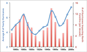
 Average number of yearly Atlantic hurricanes per decade (blue line), and number of hurricanes striking within 150 miles of North Carolina (red bars). Atlantic hurricane counts from wunderground.com/hurricane/hurrarchive.asp, North Carolina hurricane statistics from nc-climate.ncsu.edu/climate/hurricanes/statistics.php. |
Such great variability in the number hurricane landfalls demands an explanation. Intuitively, the number of landfalls reflects the total number of hurricanes: the more hurricanes in a season, the greater chance that any area could receive a direct hit. For North Carolina, the number of hurricane impacts per decade tracks the average number of yearly storms, as the accompanying chart shows.
One way to estimate the chance of a hurricane strike to a certain area is to estimate the total number of storms during a hurricane season. For such estimates, it is crucial to have accurate records of past hurricane strikes. Unfortunately, historical data are limited in length, only going back to the mid-19th century, and their accuracy and coverage are questionable at best.
For Jeff Donnelly, an associate scientist at Woods Hole Oceanographic Institution in Massachusetts, extending the historical record of hurricane strikes is a matter of digging deeper. Just not into library archives or journals; instead, Donnelly searches for evidence of hurricanes in salt marshes on the landward side of barrier islands.
Over the last two decades, scientists have increasingly turned to clues from the earth for records of past hurricane strikes. This approach, termed paleotempestology (paleo- past, tempest- storms; logy- the study of), relies on a simple principle: Hurricanes tend to move things to where they normally would not be found.
Supporter Spotlight
In salt marshes, the material moved is sand. When a hurricane approaches the coast, wave action and storm surge erodes sand from the beach and brings it inland, depositing the sand on top of the muddy sediment in the salt marsh. After the storm surge recedes, the marsh recovers, and muddy sediment is again deposited on top of the sandy layer. The end result, according to Jon Woodruff, assistant professor at University of Massachusetts-Amherst and a former student of Donnelly, is “the perfect dirt layer cake”.
Donnelly and Woodruff take cores in the landward salt marshes, and reconstruct past hurricane strikes from the sand layers in these tubes of sediment. Previous work published by Donnelly and colleagues has recovered evidence for major hurricane strikes in the 18th, 19th and early 20th centuries in the salt marshes of New Jersey, Long Island and Rhode Island that coincided with documented hurricane strikes.
But the potential doesn’t stop there. With longer sediment cores and the right location, hurricane strikes can be inferred from times long before the historical record. “Cores help us take a look at history over 5,000 years, and that’s a powerful tool,” Donnelly told a Oceanus magazine in 2009.
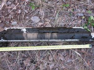
 A sediment sample collected from the Florida Panhandle. The dark sediment is mud that is normally deposited in a marsh. The lighter bands of sediment represent layers of sand that are washed into the marsh during hurricanes. Photo credit: Jon Woodruff |
A recent hurricane strike reconstruction from Puerto Rico, published in Nature, suggests that increased hurricane activity in the North Atlantic over the last 5,000 years generally corresponds to weaker El Niño events and a stronger West African monsoon.
Despite their potential, reconstructions of past hurricane strikes have proved challenging to generate from eastern North Carolina. A 2006 study by Steven Culver and colleagues from East Carolina University examined salt marsh cores from Pea Island. The authors showed that sand deposits in these salt marshes were far too variable and widespread to be explained by hurricane activity and likely related to changes in inlet positions along Pea Island. Similar research in Onslow Bay by Scott Hippensteel of University of North Carolina-Charlotte has found evidence for storm activity in Onslow Bay over the past 1,500 years.”
Hurricanes will never cease to be a risk to the residents and economy of eastern North Carolina. But with methods like paleotempestology, scientists are gaining a more complete picture of past hurricane variability and of what factors may contribute to future hurricane variability. While scientists may never be able to predict the chance of a hurricane strike in one location in any given year with certainty, research into past hurricane strikes has certainly underscored the dynamic history of the coasts we call home.


