By Pam Smith
Last of three parts
Supporter Spotlight
It’s not all bad news for the Lockwoods Folly River. Last month, The Nature Conservancy announced the acquisition of nearly 500 acres at the river’s headwaters. On the southeastern edge of the Green Swamp Preserve, the unique parcel includes a 50- to 60-foot remnant sand dune, created when the ocean retreated to the current coastline.
The ridge is surrounded by equally unique terrain with rare flora and fauna. Freshwater from Green Swamp pours into Pinch Gut Creek and thus begins a journey toward becoming a river.
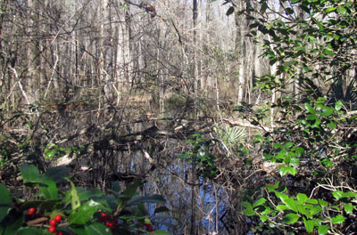 It’s easy to see how Pinch Gut Creek got its name. From this tangle, the Lockwood Folly River is born. Photo: Pam Smith |
According to Dan Ryan, the conservancy’s Southeast Coastal Plain project director, the acquisition is being funded by an anonymous donor, along with an Environmental Enhancement Fund grant from the North Carolina Department of Justice.
In addition, the N.C. Wildlife Resources Commission is negotiating the purchase 500 adjacent acres from the Natural Heritage Trust Fund.
Mike Giles, the N.C. Coastal Federation’s coastal advocate for the Cape Fear Region, says partnerships will hold the key to the future of the Lockwoods Folly River. Fortunately, there is growing awareness of the river’s importance among individuals, government agencies, conservation organizations, homeowners associations, developers and real estate groups.
Supporter Spotlight
The population of Brunswick County now stands at about 108,000 and is expected to grow to 118,000 by 2020. But, the recent economic slowdown is providing opportunities to acquire environmentally important tracts of land; time to establish new environmental partnerships; and space to develop strategies ahead of the predicted resurgence in growth.
On a recent mild winter day, Giles points the federation’s center console boat upriver. On board are Phyllis Evans, a long-time volunteer on the river, and Rich Peruggi, who is a federation board member and one of the members of the Lockwoods Folly Roundtable. The long-term effort, spearheaded by the federation and Brunswick County officials, began at the peak of county growth, when Brunswick was among the fastest-growing counties in the country. The partners wanted to get a handle on the state of the river.
From 2007 to 2008, an army of citizen scientists, affectionately dubbed the “Lockwood Army,” worked with the federation to gather water quality data. Evans and her husband, Kevin Talon, joined the army. Hans Wagoner, their neighbor in River Run Plantation, joined them. Rounding out the samplers were Tom Hetherington, Fred Leopp and Peruggi, all of another subdivision on the river, Winding River; Sunset Harbor’s Joe Taylor and Dave Pelizzari; and Varnamtown’s Hans Forester. The volunteers helped collect and analyze water samples from more than a dozen sights through all seasons
The data form the foundation for a comprehensive plan to address – and hopefully reverse – pollution trends in the Lockwoods Folly River. Solutions include encouraging the adoption of low-impact development (LID) techniques by developers to control stormwater and small-scale adaptations by homeowners. The Brunswick County Board of Commissioners approved LID as an option for developers two years ago.
Nature and Nurture
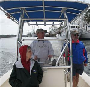 A journey on the river: Phyllis Evans, left, Mike Giles, center, and Rich Peruggi. Photo: Pam Smith |
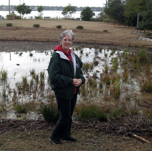 Phyllis Evans and other volunteers built this rain garden in the River Run Plantation subdivision to control stormwater. Photo: Pam Smith |
Giles guides the boat further upriver toward Varnamtown. There, a pod of dolphins briefly surface and dive – too busy feasting on the catch of the day to put on a show. Out on the mudflats, a handful of men in waders are filling croaker sacks with freshly dug oysters from one of the remaining areas open to oyster harvesting.
At Buoy 6, Giles points out the area called Eastern Bend, where the Federation soon will expand oyster habitat with 15,000 bushels of recycled oyster shells. The project is funded by an Estuary Restoration Act grant, which also will underwrite the construction of a living shoreline project along the Lockwoods Folly River. The federal law, passed in 2000, makes restoring estuaries a national priority.
Evans gestures across the river toward River Run, where she and fellow River Run residents worked with the federation’s Tracy Skrabal to create two rain gardens near the community boat ramp and fishing pier. The gardens intercept and filter stormwater flowing from the development’s roadways before it reaches the river.
Passing Winding River Plantation, Peruggi calls attention to waterfront parcels where some homeowners have maintained natural, living shorelines. Another has built an experimental, semi-open bulkhead that buffers wave energy and fosters the growth of natural marsh grass close to shore.
Peruggi recruited fellow Winding River residents, including Pam Duncan, to work with the federation to create two rain gardens near the community’s 21-slip marina to help prevent stormwater from rushing into the river from adjacent parking areas.
Hetherington, who serves on the marina committee, continues to champion the river’s cause. He is researching the most environmentally sound way to proceed with a needed marine overhaul. One possibility is to replace part of the bulkhead with a living shoreline to mitigate sediment deposits in the boat channel.
Peruggi serves on the environmental issues committee for the Alliance of Brunswick County Property Owners Associations. He is spreading the word about how homeowner associations and individual homeowners can protect water quality across the county.
Along with the construction of rain gardens, individuals may opt to install rain barrels to harvest rainwater for lawn and garden irrigation; plant native plants, trees and shrubs that are suited to local conditions; or simply redirect downspouts away from sidewalks or driveways and into landscaped areas.
The Eagle Has Landed
Just past Winding River Plantation, lies a stretch of waterfront property the long-time resident and owner placed into conservancy a number of years ago. It is a magnificent expanse of thick marsh accentuated by water sparkling around and through the waving grasses.
 A trip up the river ends with the stirring sight of a bald eagle. Photo: Pam Smith |
“There is no telling the extent of wildlife that is hidden in that acreage,” Giles notes.
Beyond the bend sits remnants of Brunswick County’s past and recent history: a crumpling house, the victim of time; and, an abandoned fishing dock, the victim of a crumpling economy.
Further on, Giles passes a make-shift boat launch.
“That’s what the locals call the fishing hole,” Peruggi says. “It’s actually about 20 or 30 feet deep at high tide. This is the deep-water area where the shrimp boats tie up when a storm threatens the coast.”
From here on, the scenery is wild and wonderful. Cypress trees – their lives cut short by saltwater intrusion and countless storms – stand tall above the banks of the deep and winding water.
Evans spots the silhouette of a large bird atop a “toothpick” of a tree in the distance. It may be an osprey, hawk or perhaps a buzzard. But as the boat rounds the curve in the river, the tall stick of a tree is right there within a few feet from the bank. The treetop occupant clearly is a bald eagle.
Giles slows the boat to a near stop for a longer view while the eagle patiently poses, waiting for the viewers to believe their eyes.
“Now, where else can you have nature come right to you,” Giles observes.
When Giles reaches the N.C. 211 Bridge, he’s tempted to stretch the tour a bit further. The river is wide and promising beyond the bridge. But, he doesn’t want to take the chance of losing the tide. After all, it’s a 12-mile return trip to the boat launch at Sunset Harbor. Running aground would put a damper on the day.
After all, the nature score card is pretty amazing – dolphins, pelicans, egrets, assorted waterfowl – and three eagles – and no mosquitoes, snakes or alligators.
It doesn’t get much better than that.


