Second and final in a series
As the North Carolina Coastal Resources Commission’s Science Panel studies the effects of permanent beach erosion control structures such as seawalls and jetties, a critical aspect of the analysis will be looking at the lessons learned.
Supporter Spotlight

The commission banned hardened structures on the ocean shoreline in 1985 because of the down-shore erosive effects on the beach. Still, there are numerous examples of such structures in place along different parts of the coast, with varied degrees of effectiveness.
Erosion is not only more severe and longstanding on the Outer Banks, which are more exposed to the power of the open ocean and coastal storms than other parts of the North Carolina coast, it is the most dramatic and unforgiving, especially on Hatteras and Ocracoke islands. But coastal erosion is a statewide issue. To that point, federal beach nourishment projects in North Carolina began in 1965 at Wrightsville Beach and at Carolina Beach, and nourishment at both locations has been done in recent years.
When development and tourism took off on the Outer Banks in the 1980s, it didn’t take long before beach cottages began lining ocean shorelines.
Still, the forces of erosion had no mercy, and Kitty Hawk began losing beachfront properties. After the commission issued a variance to the hardened structures ban in 2003, permitting sheet-piling along N.C. Highway 12 in the beach community, then-Sen. Marc Basnight strongarmed the state’s ban into legislation.
Then in 2011, the North Carolina General Assembly passed a law that permitted four “test” terminal groins and has since expanded the permissible number of groins to seven. To date, four communities submitted permit applications: Figure Eight Island, Ocean Isle Beach, Bald Head Island and Holden Beach. Holden Beach has since withdrawn its application.
Supporter Spotlight

Long before the ban, numerous attempts were made to shore up the beach oceanward of the 1870 Cape Hatteras Lighthouse in Buxton. By 1930, the nation’s tallest brick lighthouse was a mere 98 feet from the ocean.
According to National Park Service records, interlocking steel sheet-pile groins were installed in the 1930s on the beach near the lighthouse and reinforced a few years later. Over the years, dunes were built, grasses were planted, the beach was nourished, revetment and sandbag walls were installed.
In 1969, the U.S. Navy installed three reinforced concrete groins to protect its base, which was adjacent to the lighthouse at the time. But the erosion continued. More sandbags were put in place; more beach nourishment was done. The Navy left in the 1980s. While the National Park Service officially gave up its beach nourishment and dune stabilization efforts in 1973, it continued trying in ensuing years to protect the lighthouse from the sea with rip-rap, artificial seagrass, sandbags and a scour-mat apron.
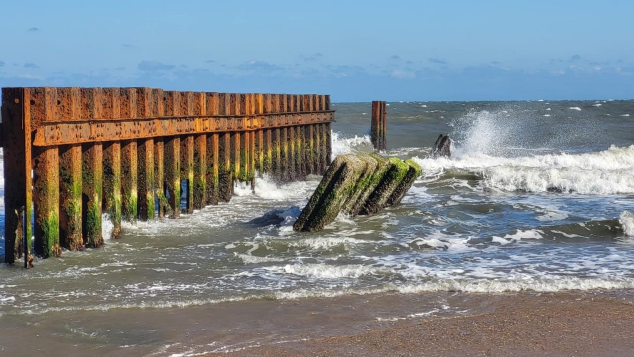
Finally, after much study and public debate, with the ocean lapping at its foundation, in 1999 the lighthouse was relocated about a half mile from the beach.
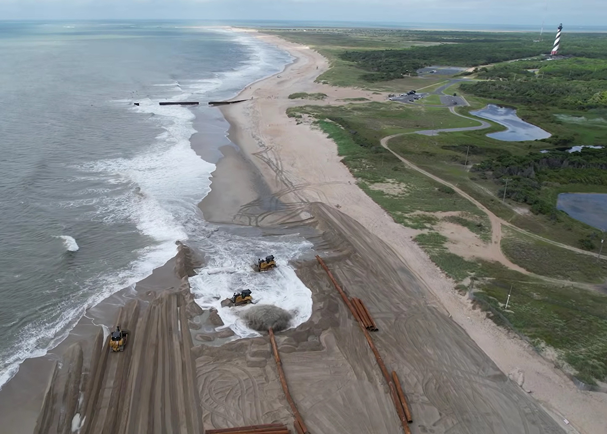
Fast-forward a quarter-century and, since September 2025, 19 unoccupied beach houses near that same beach in Buxton have collapsed into the ocean.
Escalating beach erosion along the state’s entire coast, but especially in Buxton, has put difficult discussions about lifting the hardened shorelines ban back on the table. The few existing permanent erosion-control structures built over the years on North Carolina beaches have yielded mixed results.
Oregon Inlet
One of the most successful examples of a terminal groin doing what it was intended to do, and with relatively minimal harm, is the 3,125-foot terminal groin and 625-foot revetment built in 1991 to protect the N.C. Highway 12 tie-in at the Herbert C. Bonner Bridge, which has since been replaced and renamed the Marc Basnight Bridge. The $13.4 million groin is substantial — ranging from 110 to 170 feet wide at its base and 25 feet wide at its landward end, and 39 feet wide at its seaward end — and was built to withstand waves as high as 15 feet, according to an analysis done by the state Division of Coastal Management, “North Carolina’s Terminal Groins at Oregon Inlet and Fort Macon, Descriptions and Discussions.”
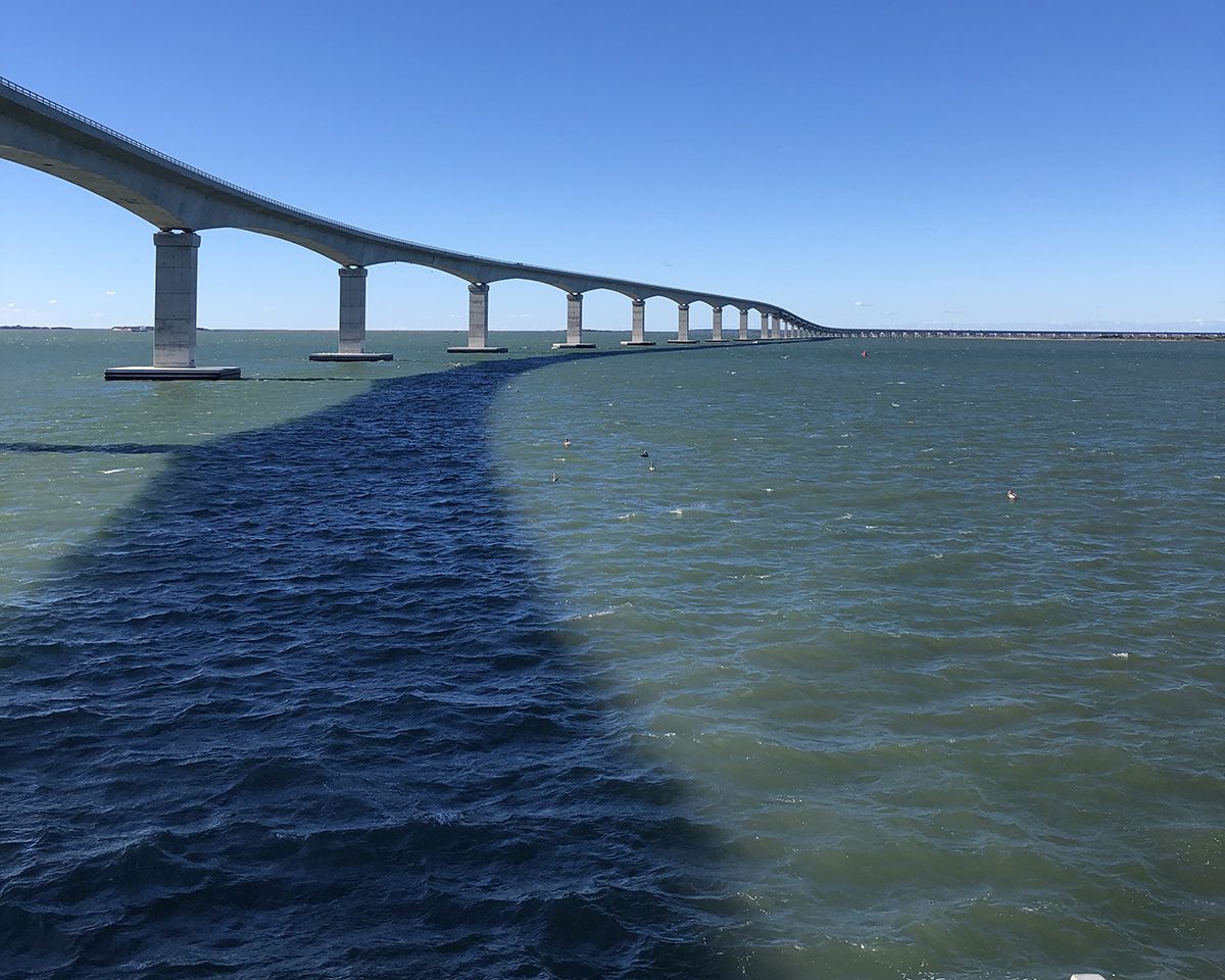
Located on the south side of Oregon Inlet at the north edge of Pea Island National Wildlife Refuge land, the groin placement encouraged sand buildup, or accretion, landward, resulting in a wide expansion of 50 acres of sandy property on the inlet side of the historic state-owned Oregon Inlet Life-Saving Station. The building is vacant, but has been weatherized to preserve it for future use.
The groin site and surrounding beach have been regularly monitored by state and federal coastal scientists. Studies have shown that the structure has likely increased shoaling of a spit on the Bodie island side and deepening of the channel. Yet, the groin has cause little if any destructive downstream erosion while adequately protecting the highway and bridge infrastructure.
But the report warned that within the next 20 years or so, the continued southward migration of the Bodie Island spit could push the inlet’s main navigational channel up against the terminal groin structure itself.
“If this were to occur, the result would be severe scour and an increase in the maintenance necessary to preserve the threatened integrity of the structure itself,” according to the document.
Beaufort Inlet/Fort Macon
Since Fort Macon was constructed in 1834, about 25 erosion-control structures adjacent to Beaufort Inlet have been built, including groins, breakwaters, timber cribbing, sand-fencing and seawalls, as well as multiple beach nourishment projects, according to the terminal groin report. The first phase of the terminal groin project began in 1961 and included a 530-foot seawall, a 250-foot revetment and 720-foot long, 6-foot-high terminal groin. Phase II, beginning in 1965, extended the groin 410 feet oceanward, and another groin was built west of the revetment to address extensive soundside erosion, while 93,000 cubic yards of sand was placed on the ocean beach.
The third phase, started in 1970, extended the terminal groin another 400 feet, to a total of 1,530 feet long. A 480-foot-long stone groin was built to stabilize the beach fill, and another 100,000 cubic yards of sand was placed on the ocean beach. Total costs for the three-phase project was $1.35 million.
Effects of the project include increased wave energy along the Fort Macon State Park and Bogue Banks area, and continued increases in wave energy were predicted. A sediment deficit has created erosion on the inlet’s western shoreline. Meanwhile, the sand spit at Fort Macon has migrated into the western bank of the navigation channel, indicating that the terminal groin has become inefficient at trapping sediment.
“Without constant beach nourishment, the terminal groin would no longer perform as observed historically and potentially fail altogether,” the report concluded.
Buxton
Dare County is planning a nourishment project in Buxton, as well as restoration of one of the Navy’s three abandoned reinforced sheet-pile groins that had been installed in 1969. According to the recent application to repair the southernmost groin, which is 50% or more intact, that groin had been lengthened in 1982 on the landward side by 300 feet, and armor stone was added two years later. New sheet piles and additional scour protection were added to the structures in 1994. The other two groins in the original groin field are too damaged to qualify under the Coastal Resources Commission’s “50% rule” that permits repairs.
Dare County Manager Bobby Outten has said publicly that the county is under no illusions that the project planned for this summer will solve the erosion issue for good. But the hope is that it will serve as a Band-Aid long enough to find a more permanent solution to erosion that is now so severe it is threatening the livelihoods of community residents and the island’s tourism economy, as well as N.C Highway 12.
Retired East Carolina University professor and veteran coastal geologist Dr. Stanley Riggs, who has studied the Outer Banks since the 1970s, agreed that the fact that the lighthouse had to be relocated to save it illustrates why Buxton’s erosion is not going to be easy to tame for long, with or without groins. When the first coastal survey from Virginia to Ocracoke was done in 1852, the original 1802 Cape Hatteras Lighthouse, which was destroyed, had been 1,000 feet from the shoreline, Riggs recently told Coastal Review. All told, the shoreline has receded 3,000 feet, or about two-thirds of a mile, at the cape, he said.
“And it’s been constant,” Riggs said. “It oscillates a little bit, but the main direction has been constant.”
As Riggs explained, offshore just north of the motel area in Buxton, there is an underwater rock structure that is set at an oblique angle relative to the barrier island. Similar “old capes” are also off Avon and Rodanthe, he said. The rocks are under as much as 50 feet of water, and they dictate how the waves refract there.
“And so, if you fly over it, and you get the right angle down there, what you see is a series of cusps, and one side of that cusp will be stable, the other side will be highly erosional,” he said. Groins will only make the eroding side erode faster. And when there are permanent or semipermanent structures along the beach, the shore face — the part that is under water — starts to erode and gets steeper and steeper, he said. And the steeper it gets, the more severe the overwash and the more difficult it is to hold the sand in place. That’s a big reason why beach nourishment is having to be done more frequently.
Not only does the Outer Banks stick out farther into the Atlantic, there is also a narrower continental shelf, which allows the bigger waves to come ashore from the open ocean without the wider “speed bump” needed to dissipate the power.
There’s no negotiating with the ocean, Riggs said. Considering the combination of coastal dynamics at play in Buxton, efforts to control erosion will continue to fail.
“It’s that land-sea-air interface that is really the highest energy place that we’ve got on our planet,” Riggs said. “And there’s some things you can do there. There’s some things you shouldn’t do there, you can’t do there, and it’s a matter of understanding how that system works.”
Ocracoke Island
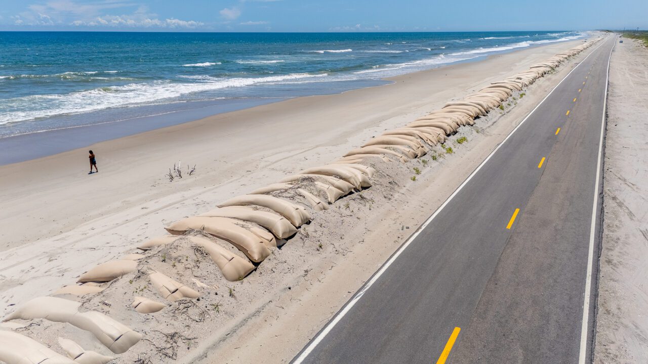
A persistent erosion hot spot on the north end of the island along N.C. Highway 12, the only road between the Hatteras Ferry Docks and Ocracoke Village, has been patched on and off for decades by increasing numbers of ever larger numbers and size of sandbags.
But even the type of large, new, trapezoidal bags permitted at Ocracoke, Pea Island and Mirlo Beach have not held up as expected, according to a presentation provided by Paul Williams of the North Carolina Department of Transportation at the February Coastal Resources Commission meeting.
Williams presented details at the meeting of NCDOT’s revised request to increase the base of the sandbags from 20 to 30 feet and the height from 6 feet to 10 feet, to better protect them from being undermined by waves.
The newer bags have open ends at the top, which proved to be a problem at Pea Island, Williams told the commission. The Pea Island Refuge at the Visitor Center, he added, faces similar risks now to that seen at Mirlo Beach in Rodanthe in the years before the hotspot was bypassed with completion of the Rodanthe “Jug-Handle” Bridge.
“The performance has not been what we anticipated,” he said, describing how they were flooded at the top, which caused the sandbags to deflate. “This product, there may be some modifications that can be made to make them more resilient.”
Some of the new bags were also installed along with traditional sandbags at Ocracoke, and they’re still covered, Williams said, but roughly 1 mile of sandbags along N.C. 12 are at risk of being undermined during the next big storm.
“So it’s basically to give us more latitude on different products, to try to protect the roadway out there better than traditional sandbags have,” Willams told Coastal Review after the meeting. “We’ve used them for decades out there, and especially Mirlo, they really got tossed around during storms. We were looking to find a more resilient product, and we’re working on evaluating other options out there.”
The new sandbags with an opening at the top are quicker to fill, he said. They’ve worked at other areas, but conditions elsewhere are not as fierce.
“When you’re on the Outer Banks, you’re under constant pressure during some of these storm events, because we’ll have a storm set up on the coast and grind for days at a time,” Williams said. “And every tide cycle is just steadily pulling sand out of the bags, and we need to have some way to stop that.”
Even though many of the traditional sandbags without the troublesome opening are still in place at Ocracoke, Williams said that about half of them, or about 1,000, have been exposed and need to be replaced. Another issue on the island is the limited amount of sand available to cover.
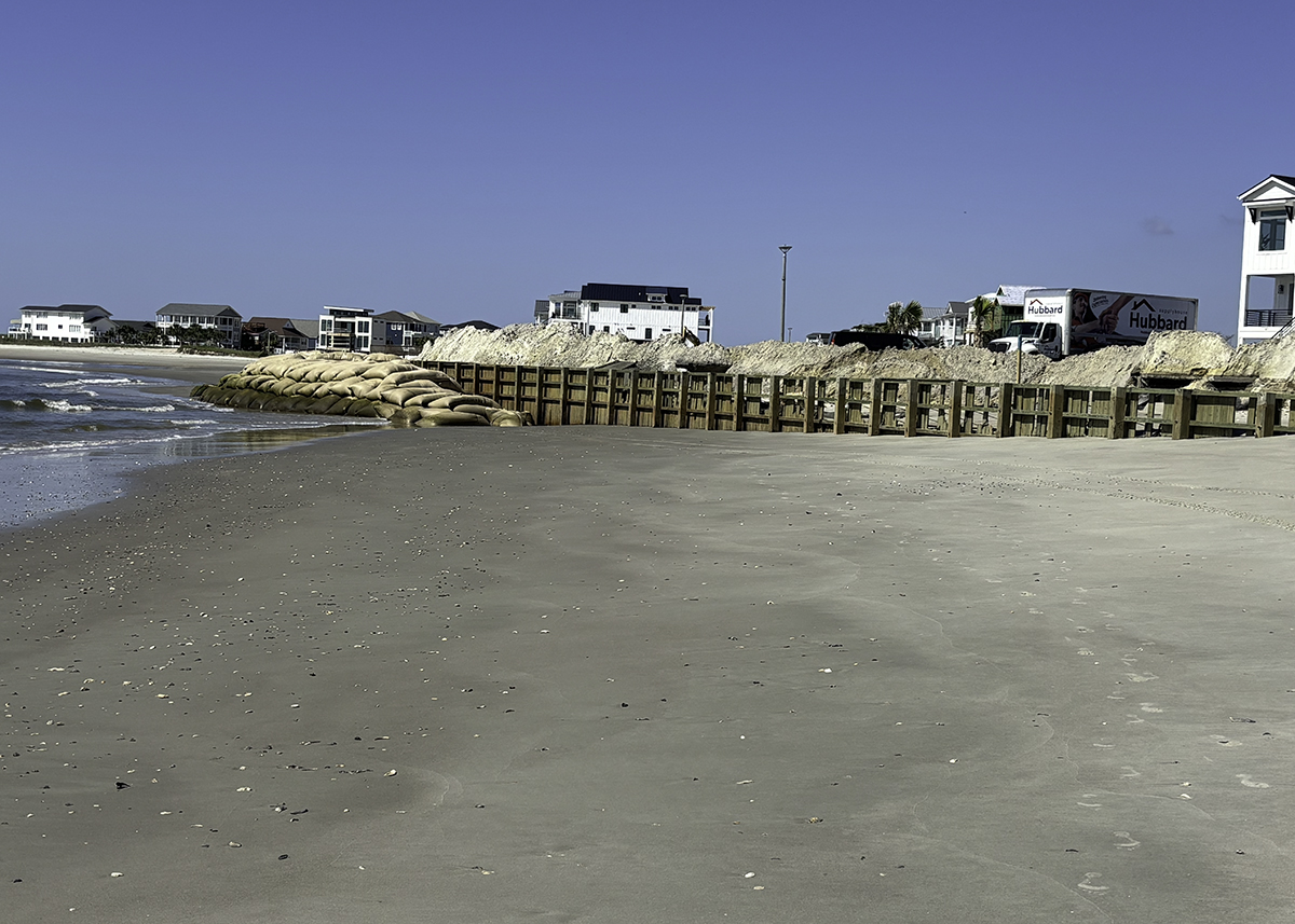
Sandbags, which are considered temporary erosion-control structures that are permitted parallel to shore to protect imminently threatened roads or structures, have rules about color and size, but those rules have been notoriously abused with regard to the “temporary” part, with extensions often adding up to decades at a site, making them “hardened structures” in everything but name.
Before Nags Head in 2011 started nourishing its eroded beaches in South Nags Head, for instance, even battered and torn sandbags weren’t removed for years, and property owners often successfully sued the state to keep longstanding stacked rows of protective bags in place in front of their oceanfront homes on the eroded beach.
As sea levels continue to rise, storms intensify and erosion accelerates, even sandbags as fallbacks in the absence of other impermissible erosion-control structures are becoming less effective, as evidenced by photographs of huge piles of sandbags lined up against undermined houses at North Topsail Beach.
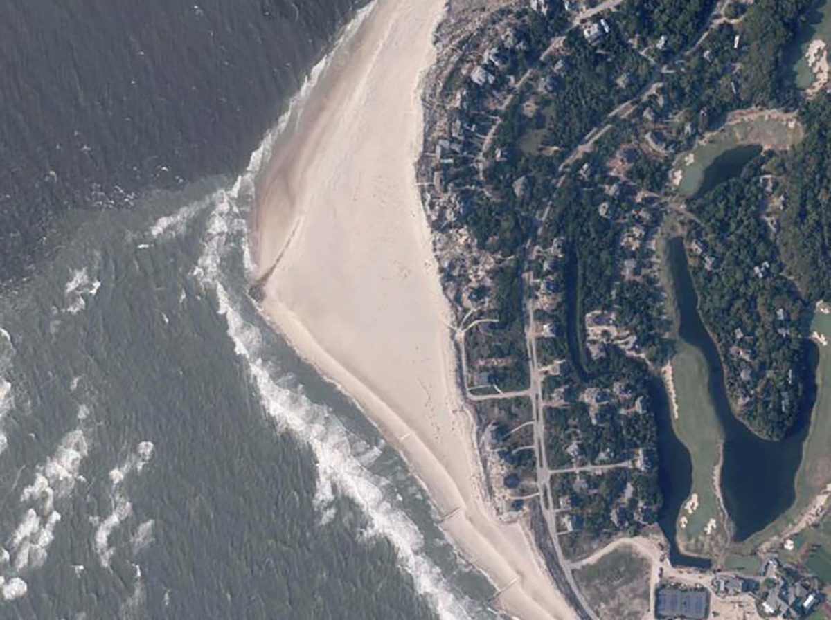
Ocean Isle Beach
Responding to the state legislature’s repeal of the ban on hardened erosion-control structures on the coast, Ocean Isle Beach in 2011 began the planning process to pursue permits to install a terminal groin at Shallotte Inlet to stem erosion that for decades had chewed away at the island’s east end. Five years later, state and federal approval was in hand to build a 750-foot-long terminal groin, but environmental groups in 2017 filed a lawsuit to stop the project. A ruling in March 2021 in the 4th Circuit U.S. Court of Appeals affirmed a lower court’s ruling that the project alternatives were properly considered. By April 2022, the $11 million terminal groin was completed.
Today, a diminished beach remains in front of multi-million-dollar homes that were built after the groin was in place. Rows of sandbags block the surf from reaching some of the oceanfront homes, and several lots remain vacant because there is no longer enough property left to meet setback requirements.
In November, the Coastal Resources Commission allowed the owners of eroding vacant oceanfront lots to use larger sandbags to protect their properties.
Interest in future terminal groins
The Village of Bald Head Island, the first community to build a terminal groin after the “test groin” law passed, was issued a permit in October 2014 to build the erosion-control structure, which was completed in 2015.
North Carolina Department of Environmental Quality monitoring of the project after its completion did not turn up significant issues requiring corrective measures, according to its January 2024 report.
“While ongoing post-construction monitoring performed by the permittee has not identified any significant issues that would require corrective or mitigative measures, the Village performed a maintenance beach nourishment event, received nourishment from the U.S. Army Corps of Engineers’ regularly scheduled Wilmington Harbor maintenance project, and is currently seeking permit authorization for a second Village-sponsored maintenance nourishment event,” according to the document.
Six other communities have expressed “varying degrees” of interest in building a terminal groin project, including North Topsail Beach and Figure Eight Island, as noted in the report.