Dave Hallac called it.
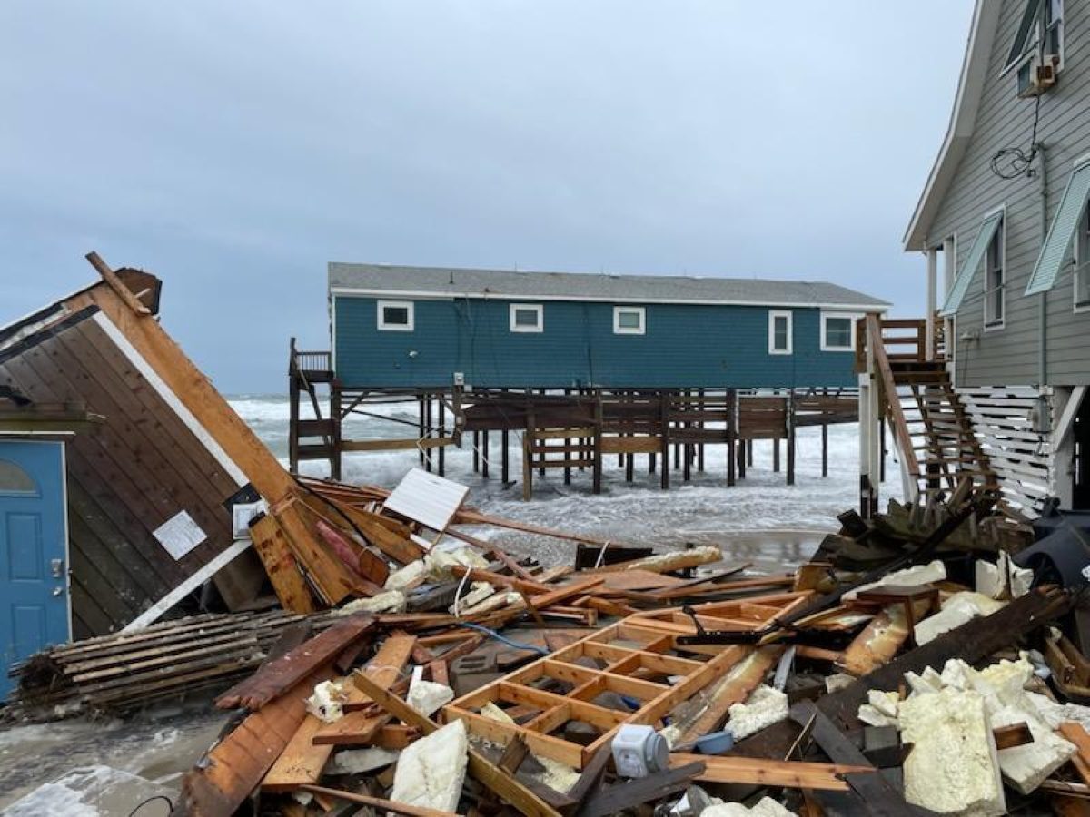
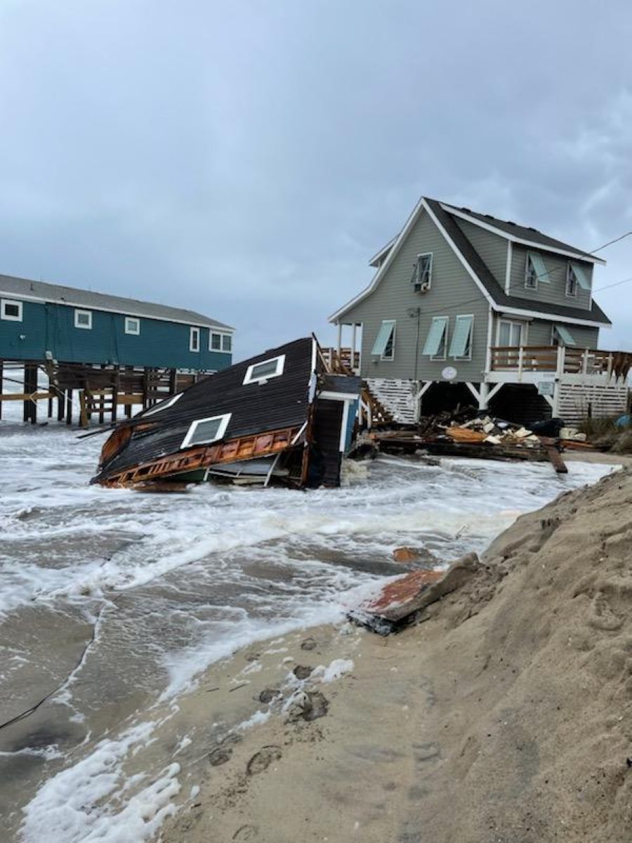
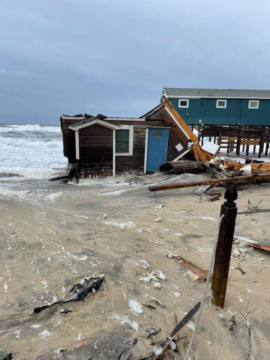
Within 48 hours, the Cape Hatteras National Seashore superintendent’s prediction came true. Another unoccupied, imperiled home on Rodanthe’s ocean shore toppled into the Atlantic Ocean.
Supporter Spotlight
“I would not be the least bit surprised with this weekend’s king tide and elevated seas from the north winds if they collapse by Sunday,” Hallac said last week to the state’s Coastal Resources Commission. “I hope that doesn’t happen, but that’s possible.”
The house that is no more at 23241 Surf Side Drive crumbled some time during the night between Thursday and Friday. Its tattered remnants littered Rodanthe’s shore, forcing the Cape Hatteras National Seashore to temporarily close the beach.
The low-pressure system that descended on the North Carolina coast Thursday evening, whipping up strong wind gusts, elevated tides and heavy rain and the closure of N.C. Highway 12 between the Basnight Bridge and Rodanthe hindered cleanup operations.
All the while, national seashore officials kept an eye on two other threatened structures Hallac said were at imminent risk of collapse.
“This is going to be one of the most significant problems that Cape Hatteras National Seashore faces and, of course, many areas of the coast,” he said last week.
Supporter Spotlight
Two years had passed since Hallac last met with the coastal commission to update its members on a situation that is becoming increasingly common along the national seashore on the Outer Banks.
Hallac made the five-hour drive to Ocean Isle Beach last week to talk about what he anticipates to be a looming increase in threatened oceanfront structures as seas rise and possible solutions to address the problem.
It’s a topic, he said, that is important not only to the national seashore, “but what we’re seeing is really the tip of the iceberg,” as problems associated with coastal erosion along, not only areas of the East Coast, but also the rest of the country’s ocean shores.
Although Rodanthe’s beachfront is not the only erosion hot spot along the North Carolina coast, it has gained notoriety in recent years as house after house after house has succumbed to powerful ocean waves that are increasingly unattenuated because of the vanishing shore.
In the two years since Hallac last spoke to the commission, 10 houses have collapsed on the national seashore. Six of those, counting the house that fell last week, have broken apart and tumbled to the ocean since May.
This is occurring in spite of decades-long efforts to keep erosion at bay in, what by all accounts, is a story of how the government tried, and failed, to hold a barrier island in place.
‘The Great Wall of Carolina’
The story goes back more than 80 years, when Congress authorized the creation of the park — the first national seashore — in August 1937.
During that time, single men aged 18 to 25 could enlist in the Civilian Conservation Corps, one of a series of programs created under President Franklin Roosevelt’s New Deal, a government work program aimed at lifting the nation out of the Great Depression.
Roosevelt established the conservation corps in 1933 to improve America’s parks, public lands and forests.
Cape Hatteras National Seashore was officially established in 1953. The park includes 75 miles of ocean-facing beaches spanning portions of Dare and Hyde counties.
Within its boundaries are three lighthouses, two fishing piers, two marinas, two boat ramps and three airports.
More than 150,000 people stayed overnight last year in its four beach campgrounds. During that same time, the national seashore had more than 3 million visits, ones Hallac described as long-duration, high-density visits where people rent beach homes and stay for a week.
Nine villages are either adjacent to or within the national seashore, one with a dune system that was largely built by the conservation corps.
Workers in the program erected more than 600 miles of sand fencing – called The Great Wall of Carolina – during a dune-building effort, which Hallac said was “really the beginning of the fight-the-ocean stage.”
The black and white photographs Hallac displayed on a projection screen for the Coastal Resources Commission last week showed park service employees in the 1950s planting American beach grass to try and stabilize the dunes that had been partially created by the fencing.
In all, more than 13 million square feet of grasses and millions of trees and shrubs were planted to try to hold in place the barrier island, Hallac said, adding, “which is really nothing more than a pile of sand.”
The park service had a helicopter for arial fertilizer spraying on the dunes to help make the grasses grow as quickly as possible. As erosion and storms kept sweeping away the ocean shore, workers kept pushing sand up from the sea, back onto the beach.
Significant erosion in Buxton was easily tracked at the Cape Hatteras Lighthouse. The nearly 200-foot-tall beacon was built 1,500 feet from shore in 1870.
By 1919, only 300 feet of sand separated the lighthouse from the Atlantic Ocean.
“So, it just goes to show you how fast the erosion is in some areas of the Outer Banks,” Hallac said.
After 37 years and more than $20 million, virtually the entire federal investment in the park’s beaches and dunes, the “erosion control program had been lost to erosion control,” Hallac said.
“We decided we were now going to follow most of the National Park Service processes, the same policies that we have in places like Shenandoah National Park, Yellowstone National Park, which is to allow natural processes to occur, including erosion,” he said. “Even after investing a lot to try to control this, we just determined we were not successful. We could not keep up with it and so here we are.”
Today, nearly 7,000 feet of sandbags have been placed within the park facing N.C. Highway 12 to try and protect the vital roadway from the ocean.
Debris ‘becomes part of the beach ecosystem’
The breathtakingly tragic scene of an oceanfront littered for miles by debris from a collapsed house doesn’t fully capture the full impact fallen houses have on the shore.
Tens if not hundreds of thousands of remnants of tar paper, the layer of material typically installed beneath roofing shingles, ends up buried in the sand, Hallac said.
“You never get rid of all of this,” he said. “The debris associated with these home collapses becomes part of the beach ecosystem.”
Hallac hires biological technicians in the summers to oversee sea turtle nests and shorebirds. The technicians spend several hours every week picking up septic drain-field cells, diverter boxes and other pieces of septic systems that wash down the beach and come to rest on areas of the national seashore.
The park keeps handy a stack of signs supplied by the North Carolina Department of Environmental Quality’s Recreational Water Quality Program to post in the event of a wastewater spill caused every time a septic tank is compromised by the encroaching sea.
There were 23 septic spills on the national seashore between Aug. 12 and Oct. 1.
“This problem is going to get much worse with sea level rise,” Hallac warned.
A gauge the National Oceanic and Atmospheric Administration keeps at Oregon Inlet is tracking sea level rise at 5.56 millimeters per year, he said.
“When I started giving presentations like this it was in the 2 millimeters per year range, and this is expected to increase. But I can tell you right now, if it doesn’t increase at all, we will have a major problem based on the presence of threatened oceanfront structures,” Hallac said.
A recent study measuring erosion rates on the national seashore show that the beach is eroding and the shoreline is moving westward.
“What you’re seeing is an endpoint erosion rate of 4 meters per year and a linear regression rate of 3 meters per year,” Hallac said. “It doesn’t matter which one you pick. They’re both very rapid erosion rates.”
At these rates, he said, it’s time to start thinking about houses that are now across the street from oceanfront homes.
There are places like Avon, where dozens of houses will become threatened unless the beachfront is perpetually renourished or they are moved, Hallac said.
Those are some of the options in what he refers to as “the four Bs: build out, build back, build up, or, ultimately, build a boat.”
Beach nourishment has been successful along many areas of the North Carolina’s coast, he said, but it is not a silver bullet solution.
Renourishments are causing “an inadvertent loss of the barrier island area,” Hallac said.
“Normal barrier islands overwash. They deposit sand in the middle of the island. They build elevation and sometimes the sand gets washed over to the sound side. The marsh colonizes. You can maintain the width of the barrier island as it migrates slowly to the west. We have completely halted all of those processes. We have drowning at the interior of our barrier islands, and we now are having significant erosion of the sound side of our barrier islands,” he said.
Hallac said there had been several public meetings and expert panels where discussions centered on financial assistance, the role of public and private insurance, and legal and regulatory hurdles associated with threatened oceanfront structures.
“And I think what we’ve done is, we’ve put forward a series of ideas for further discussion that can help advocate this issue,” he said as he wrapped up his presentation. “There is no silver bullet, as I said before, but we really do need to work on this and come together to find solutions because this is a problem that is going to get worse over time.”
Commission Chair Renee Cahoon said threatened oceanfront structures are a never-ending problem up and down the North Carolina coast.
“We’re going to have to start looking at other solutions to help mitigate the damages because what we’re not covering, we’re cover the cleanup, but we’re not covering the damage of the water as well as to our sea turtles and other wildlife that’s out there,” she said. “It’s going to continue to grow I’m afraid as sea level rise keeps happening and erosion keeps getting worse.”


