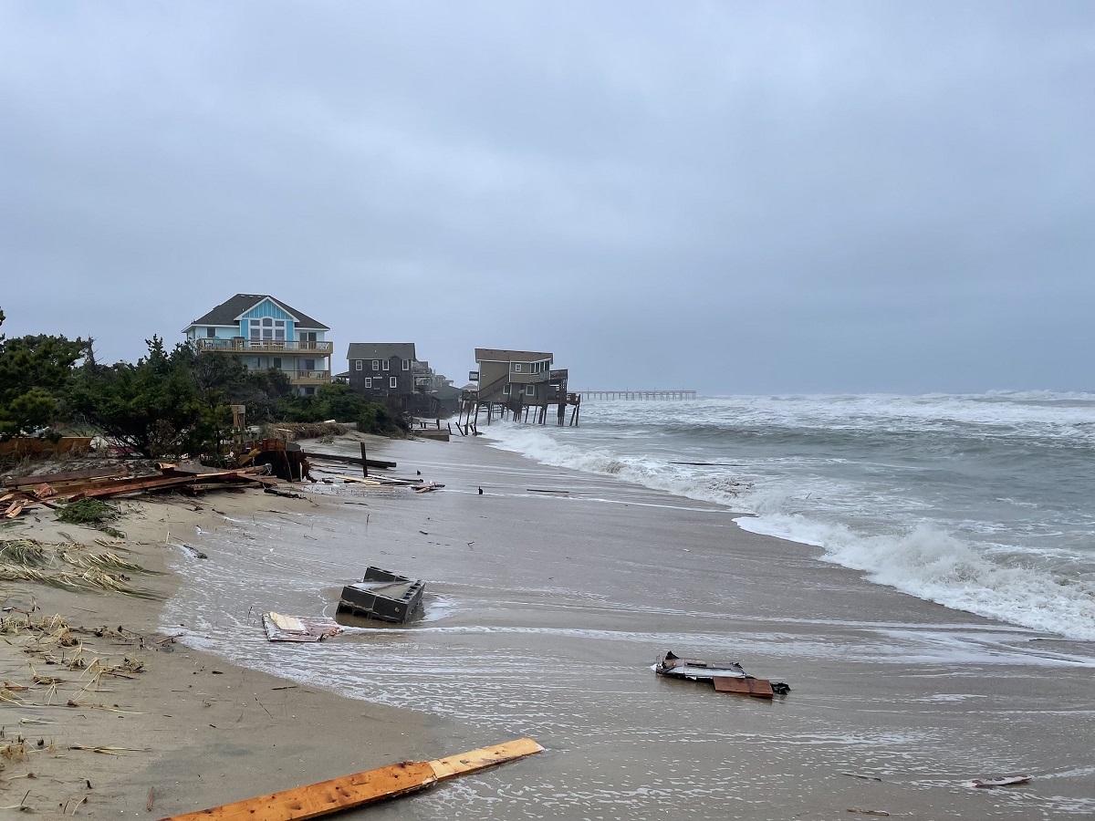
RODANTHE — Dare County commissioners voted last month to provide about $1.5 million to the U.S. Army Corps of Engineers to study the feasibility of a beach nourishment project in Rodanthe, where five oceanfront houses since 2020 have succumbed to the sea, with more still at risk.
North Carolina 3rd District Republican Rep. Greg Murphy told the county that the three-year study is required to obtain any congressional funds for a beach nourishment project, and the county must pick up half the tab.
Supporter Spotlight
“I am delighted to work with Dare County to provide the funding necessary to advance beach nourishment for Rodanthe,” Murphy said in a prepared statement dated July 27. “Preservation of the Outer Banks and its vibrant communities is one of my top priorities in Congress, and I’m grateful to work on delivering the resources necessary to do so.”
Although commissioners expressed uncertainty about how the study would proceed, Murphy said through a spokesman that the study has been authorized since 1990 and the Corps has assured that it is committed to conduct the study if it is funded.
The Corps would be able to begin work once the first increments of the study are funded, Murphy’s spokesman Alexander Crane said in a July 29 email response to Coastal Review. The county’s share would be expected after the Corps has the federal funds in hand, he explained.
“Yes, the study is a precursor to requesting federal funding for beach nourishment,” Crane wrote. “The amount of federal funding for beach nourishment will be determined later on by Congress and the results of the feasibility study.”
Crane said that the next step in the process would be an appropriations request by Murphy in the February-March time frame of next year, to be included in the fiscal 2025 budget. Those dollars would fund the federal portion of the feasibility study.
Supporter Spotlight
Property owners along the severely eroded shoreline on the north end of Hatteras Island started asking for the project years ago and with dramatically increased urgency as erosion worsened, especially at Mirlo Beach, the village’s northernmost subdivision. Even before the $145 million “jug-handle” bridge opened last summer, bypassing Mirlo and the section of N.C. Highway 12 that was frequently damaged by ocean and sound storm tide, the houses located farther south near the Rodanthe pier started collapsing into the ocean.
For months, federal, state and local officials have struggled to address a multitude of issues exposed by the tenuous and ongoing situation — property insurance, private property rights and liabilities, public safety and health, governments’ roles and responsibilities to protect public shorelines and accelerating climate change hazards — with few answers.
For numerous reasons, nourishment has not been considered a viable option for Rodanthe. Some coastal geologists have long argued that with Rodanthe’s extraordinary erosion rates on both ocean and sound sides, the village had no business being developed in the first place.
“An aerial view shows that Rodanthe is actually on a small, deteriorating cape extending out to sea,” according to a description in “The North Carolina Shore and Its Barrier Islands, Restless Ribbons of Sand.” “Rodanthe is an extremely high-risk community.”
The book’s six authors, coastal scientists who included Orrin Pilkey from Duke University and Stan Riggs from East Carolina University, now both semi-retired, warned that Rodanthe was rapidly narrowing, with an average annual erosion rate of 5 to 22 feet, and was at risk of becoming an inlet.
“THIS AREA IS EXTREMELY DANGEROUS AND SHOULD BE AVOIDED!” the authors wrote, emphasizing the statement with an unusual use of bold, uppercase letters.
And that was the assessment of coastal scientists 25 years ago, when the book was published in 1998. Since then, the average annual erosion rate in Rodanthe has not only increased, it seems as if it has worsened faster in some areas, such as where the houses are falling.
In May, Columbia, South Carolina-based Coastal Science and Engineering released an updated report requested by Dare County on a sand analysis it had done in 2014 for the county at Rodanthe. According to the report, a 5.7-mile-long critically eroded area between the south end of Pea Island and the north end of the village of Waves, has a baseline deficit of 2.3 million cubic yards of sand, and it’s losing about 300,000 cubic yards a year. At that rate, it would require about 3.8 million cubic yards of sand at today’s cost of about $40 million to offset five years of erosion.
Patrick Barrineau, coastal scientist and project manager for Coastal Science and Engineering, said the report, which compared the condition and the location of the beach in 2023 to that of 2014, was intended as an initial step toward a more comprehensive analysis.
For instance, he said, if the Corps does its study, it will likely include an economic cost-benefit analysis, a sea level and climate analysis and analysis of more physical surveys. Also, the report looked qualitatively at what to expect with different sea levels.
“A more complete modeling analysis would put quantitative measure on those predictions,” he told Coastal Review.
In looking at the changes in volume of sand, which is measured from the beach out into surf, there was still some sand remaining — “Probably not very much,” he added — from an emergency nourishment project the Corps had done in 2014 to protect N.C. 12 until the new Rodanthe bridge was built.
The volumetric changes were measured out into 40 to 50 feet of water, which details “sort of a three-dimensional change in the beach surface,” he said. Horizontal changes are just looking at the high-water line. Most people would describe the erosion rate with the horizontal measurement. Today, the annual erosion rate in the critical area ranges from 14 feet to about 20 feet.
According to the report, the variations in volume can be attributed to the coastal dynamics: Overwash at Pea Island draws sand from the beach system and stores it, reducing it in Rodanthe; and the most eroded shorelines are situated near closed breaches, such as at Mirlo, making them vulnerable to again becoming inlets.
Bottom line, it would take a lot of sand and frequent nourishment to keep a wide beach in Rodanthe, Barrineau agreed.
“Yes, definitely,” he said. “I mean it’s going to take on the order of millions of yards of sand to maintain the shoreline in a place where it’s naturally eroding at the rate that we see at Mirlo Beach just to accommodate for that and year-to-year change in the sand volume on the beach.”
Adding the impacts of sea level rise, especially where there is minimal dune, could exacerbate the issue with storm-cut channels and overwash, he said. But unlike for some beaches along the southern North Carolina coast, Barrineau said he doesn’t think there’d be a problem finding sand borrow areas to keep up with the nourishment demand.
“There’s a lot of sand out there,” he said.
If a groin — a wall that traps sand — were to be added to the project, it would cost about $15 million and could prolong the length of time the beach would stay put. Over a 30-year period, the report said, a nourishment-only management strategy would cost about $40 million more than a strategy using groins as well as nourishment.
“We’ve seen that in other sites where the groins can slow erosion along a project site and in doing so, they can extend the project lifetime,” Barrineau said. “And so, while it’s more expensive up front, it may be cheaper over a 30-year time horizon to have those in place.”
Hardened structures like groins and jetties, however, are not permitted in North Carolina. They were included in the analysis to “have in the tool box,” he said.
But barring a change in state law, groins aren’t going to be an option if a beach nourishment project ever does get approved and funded for Rodanthe. Barrineau said that the best chance for such geologically vulnerable locations to keep its beach is more substantial dunes that are taller and wider to be able to withstand pounding waves.
“It’s pretty unlikely that an entire project would be removed from a site in one storm,” he said. “Now, that being said, major Category 5-type storms do strange things. And it can be difficult to predict.”
Corps projects are not eligible for emergency federal funds for renourishment after storms, he added.
Dare County Manager Bobby Outten said that the county has about $8 to $10 million available for a new project from money set aside for beach nourishment done in the county and its oceanfront towns.
The county’s beach nourishment fund is restricted by state law to use a 2% share of Dare County’s occupancy tax, which totals 6%, for the placement of sand and planting of vegetation to widen the beach. In addition to the county fund, beach nourishment projects may also be funded by property and municipal service district taxes, and state and federal public assistance program funds.
“In our preliminary modeling, if we had a $40 million project, then in three to five years, we would have enough money to build the project and maintain it,” he said, calculating on the fund’s current rate of growth.
Outten said the county did not specifically ask consultant Coastal Science and Engineering to include data about the potential impact of sand-trapping groins on a beach nourishment project.
“They know we can’t do groins,” he said, referring to the fact that “hardened structures” on shorelines are not permitted in North Carolina. But he doesn’t rule out asking in the future.
If the feasibility study or a federally funded beach nourishment project do not move forward, then Outten said that the county would continue to look for other funding sources.
Along with other coastal counties in North Carolina, he said, Dare County has asked the state to update the Beach Inlet Management Plan to help pay for shoreline-widening projects.
“The idea is, we need a state fund for beach nourishment,” Outten said.


