Reprinted from Island Free Press
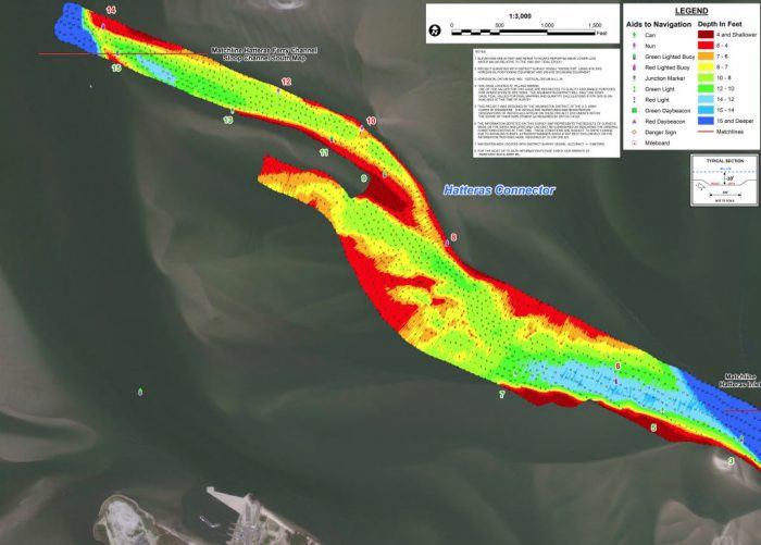
Underwater power lines crossing Hatteras Inlet’s Connector Channel have created another delay in finalizing the realignment of the Hatteras ferry channel, also known as the Rollinson Channel.
Supporter Spotlight
Shortly before Oct. 24, when the Army Corps of Engineers was expected to sign off on the draft environmental assessment, or EA, the agency decided that it needed more information about the cables, Coley Cordeiro, civil works project manager at the Corps’ Wilmington district, told the Dare County Waterways Commission.
“We were pretty close to signing on the dotted line, and then this cable issue came up,” she said, calling into the meeting held Nov. 14 at the Dare County Administration Building in Manteo.
But she assured the panel that it shouldn’t be much longer before the issue is resolved.
“We’re working that into the environmental assessment,” she said, “and we should have that buttoned up by the end of November.”
The inlet channels are currently under state and federal jurisdictions, with only a portion of them authorized for federal funding or dredging, including the Hatteras Ferry Channel.
Supporter Spotlight
Commissioners have been frustrated for years by having to obtain different permits and funds to address shoaling, an inefficient and costly process. Once the realignment is in place, it would expand federal authorization for dredging in the inlet and allow more flexible and responsive maintenance and emergency dredging year-round.
Initially, the Hatteras Ferry Channel Realignment Draft Environmental Assessment, released in October 2021, was expected to be approved by April, but finalization has been stymied by additional review requirements to include the Connector, or Connecting, Channel in the EA and to determine impacts on submerged aquatic vegetation, among other reasons.
Commission Chairman Steve “Creature” Coulter seemed baffled at the recently stalled progress.
“That cable’s been there for a long time,” he noted. “It’s just kind of strange that it’s causing this delay at the end.”
Army Corps of Engineers Navigation Branch Chief Jeremy Smith, also speaking remotely, explained that the depth of the cables needed to be confirmed. There are three lines, but only one of them, which stretches to Ocracoke, is energized. The other two lines are abandoned or disconnected. There would be a 100-foot buffer on either side of the lines for dredging.
“It’s all about the safety for the crew, and safely getting power to the island,” he said. “We’re not going to risk either one of those.”
According to Ken Willson, Dare County dredge projects consultant with Coastal Planning & Engineering of North Carolina, there are GPS coordinates for the cable locations, but the depth of the live line needs to be verified.
“We have been talking to the power company,” he said. “They speak very confidently that the (line) has not changed since it was put in, that is, between 8 to 12 feet deep.”
Willson added that more discussion is expected about the inactive lines.
Commissioner Ernie Foster asked Willson if there was any way to remove the abandoned cables.
“I’m sure it can be done,” he responded. “It’s just a matter of who will pay for it.”
In addition to the glitch with the realignment, there will also be a wait for expected dredging in the Connector Channel.
The Corps’ dredge Merritt had been planned to work earlier this fall in the channel, but it ended up being diverted to work in Carolina Beach and then Oregon Inlet, where it broke a rudder, explained Barton Grover, Dare County grants and waterways administrator.
Grover said in a later interview that once the Merritt is repaired at Manns Harbor and able to finish its work in Oregon Inlet, the hope is that it will be able to go to Hatteras sometime in mid-December.
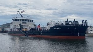
Then, if the Oregon Inlet Task Force gives its approval, he said, the Dare County dredge Miss Katie will be able to leave Oregon Inlet and do additional cleanup in the Connector Channel behind the Merritt.
The county has received a one-time permit modification to dredge in Hatteras Inlet for seven days while waiting for the alignment to go through, he added.
“We were covering our bases,” Grover said. “Now with all the delays, I’m glad we did.”
This story is provided courtesy of the Island Free Press, a digital newspaper covering Hatteras and Ocracoke islands. Coastal Review Online is partnering with the Free Press to provide readers with more environmental and lifestyle stories of interest along our coast.


