NAVASSA – What happens to the land where a former wood-treatment plant operated in this town for decades – who will own it and how it will be developed – weighs on the minds of residents here as government agencies prepare to roll out plans detailing proposed restoration of the property and how contaminated areas on the site will be cleaned.

Residents peppered government officials with questions about the future of the former Kerr-McGee Chemical Corp. Superfund site toward the tail-end of a two-hour quarterly meeting Tuesday night.
Supporter Spotlight
Can the land be deeded to the town? Who has expressed interest in the property? What is the time frame in which organizations or groups within the town have to petition for a portion of the land?
“It’s been five years,” Navassa Mayor Eulis Willis said, referring to the time when discussions began about remediating and reusing the site.
Anjie Ackerman, planning specialist with the North Carolina Division of Environmental Quality’s Division of Mitigation Service’s Watershed Planning & Property Protection section, said she understood residents’ frustration.
“I get it,” she said.
A draft restoration plan identifying the preferred proposed uses for the land will be released some time later this year, Ackerman said.
Supporter Spotlight
“I can’t guarantee you a timeline,” she said. “Our vision is to have this draft out this summer and then have a 45-day comment period.”
Officials with the state Department of Environmental Quality, U.S. Fish & Wildlife Service and National Oceanic and Atmospheric Administration have been reviewing more than 20 submitted proposals on how the land should be used.
“We have made a lot of progress on this restoration plan in the last four months,” Ackerman said. “It’s cumbersome.”

A public meeting will be held in addition to the comment period once the draft plan is released to the public.
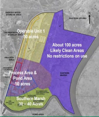
The location and level of contamination will help determine what types of development and where such development may occur on the 250-acre site.
Last April, Erik Spalvins, the Environmental Protection Agency’s remedial project manager for the site, said officials will likely not ask for land use restrictions on 100 acres of the site that are free of contamination.
The EPA will, however, place land-use restrictions on areas contaminated by creosote, including 50 acres where the former processing area and unlined ponds collecting wastewater generated during wood-treating operations were located.
Creosote is a gummy, tar-like mix of hundreds of chemicals used as a wood preservative.
Various companies operated the facility from 1936 through 1974, coating logs in creosote then stacking and drying them before loading them onto trains and transporting them offsite.
The property was added to the National Priorities List of federal Superfund sites in 2010 because of the contamination in the groundwater, soil and sediment.
To date, 485 soil samples have been collected in 323 locations on the property. Another 225 sediment samples primarily in the marsh area of the property have been collected. Nearly 550 groundwater samples have been collected from 59 groundwater wells on and off the site in addition to 193 subsurface samples and 20 surface water samples.
Groundwater wells are being tested every six months.
Tests continue to indicate that a contamination plume on the site is stable.
Richard Elliott, the Multistate Environmental Response Trust Project manager of the Superfund site, showed two maps of the plume – one showing the area of contamination in March 2017 and the other in April of this year.

The results, he said, are “very, very similar.”
“It wiggles around a little bit, but it doesn’t look like it’s going anywhere,” Elliott said.
Tests indicate that about 3 ½ acres within a 35-acre marsh on the southern portion of the property are contaminated above toxic standards.
“What we’re trying to understand here is where’s the real threshold in our marsh,” Elliott said. “There are a lot of dynamics going on and certainly one thing about the marshes is if we don’t have to go in there and dig holes in the marsh that’s a good thing. We’re going to be doing some additional sampling to get more data.”
Once the boundaries of the Superfund site have been determined, that land will be divided into operable units. By breaking the land into these units, officials are able to identify specific problems and determine the best course of action for cleanup within each unit.
These units can be adjusted as needed, Spalvins said.
A record of decision, the document that sets the remediation method chosen for those operable units, is expected to be released to the public later this year.
“This community has had a piece of it that has been out of service for decades,” Spalvins said. “So, the ability for the local community to steer what happens to it … I think is very important.”
Navassa residents through a series of workshops have shared their ideas about how they want the land to be used.
“People want jobs. People want a tax base to help the town. People want some green space and some recreational area,” Elliott said.
If the town wants the property it will need to make that request, he said.
The next quarterly meeting is set for Sept. 24.


