OCEAN ISLE BEACH – New boundaries and rules governing development at about half of North Carolina’s inlets may be adopted next year.
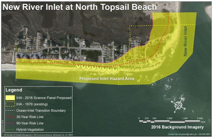
Currently a little more than 2,800 acres of land is designated within inlet hazard areas, or IHA, boundaries at 10 of the 19 active inlets in the state.
Supporter Spotlight
The science panel that advises the state’s Coastal Resources Commission recently presented to the commission proposed changes to IHA boundaries at those 10 inlets.
The proposed maps expand IHAs collectively by a little more than 1,830 acres and remove about 470 acres from existing boundaries.
A majority of IHAs would gain ground under the proposed boundaries. Acreage would be reduced at three inlets, including Tubbs Inlet at Sunset Beach and Ocean Isle Beach in Brunswick County, Mason Inlet at Wrightsville Beach and Figure Eight Island in New Hanover County, and in Pender County New Topsail Inlet at Lea-Hutaff Island.
Undeveloped inlets within state or federal management lands, such as Oregon Inlet, were excluded from the science panel’s yearslong study.
IHAs are defined as shorelines especially vulnerable to erosion and flooding where inlets can shift suddenly and dramatically.
Supporter Spotlight
“Inlets are complicated,” science panel member Bill Birkemeier said during a presentation at the CRC’s Nov. 29 meeting.

Inlets typically move over time in one of two ways. An inlet migrates, meaning it moves in one general direction, or it oscillates, wagging back and forth.
About five of the state’s inlets migrate, Birkemeier said. The rest are oscillating inlets.
Because no two inlets are alike, the challenge for the science panel has been to develop a method that fairly defines IHAs.
When IHAs were first drawn in late 1970s they were established based on the historic migration of the inlet shoreline.
The science panel determined that using the hybrid vegetation line, or landward most position of the historic vegetation line, is a more equitable method in determining an IHA.
Each new proposed boundary was created based on the annual inlet-shoreline erosion rate and the “30-year risk line” and the “90-year risk line.” The 30-year line is calculated by multiplying the annual inlet shore erosion rate by 30 and measuring landward from the hybrid vegetation line. The 90-year line is multiplied by 90 and measured landward from the hybrid vegetation line.
Birkemeier said that the method is objective and, for the most part, works at all 10 inlets the science panel has been studying for more than a decade.
Talk of updating IHA maps stretches back to 1998-99, when members of the first-appointed science panel suggested to the commission the boundaries were outdated.
About 10 years passed before the state Division of Coastal Management, or DCM, presented updated boundaries to the CRC around 2010.
The proposed boundaries were larger, prompting a host of questions and concerns that essentially pushed back progress on updating the IHAs.
It would be several years before the science panel studied the inlets: Tubbs, Shallotte and Lockwood Folly inlets in Brunswick County, Carolina Beach, Masonboro, Mason and Rich inlets in New Hanover County, New Topsail and New River inlets in Pender County and Bogue Inlet in Carteret County.
During the 40 years that have passed since IHAs were initially established, three inlets have closed and two have moved outside their original boundaries.
The science panel’s recommendations to the CRC include updating the IHAs every five years.
What may change
Long-term erosion rates are about five times greater at oceanfront shorelines near inlets.
“Inlet shorelines can also fluctuate much more than those farther away from the inlets,” according to a Nov. 15 DCM memorandum to the CRC. “These fluctuations may not increase the overall erosion rate but still contribute to the short-term risk to development.”
Rules governing development within IHAs were established to control density and structure size along the shorelines affected by the dynamic waterways.
“Right now (the rules) separate residential and commercial,” development, said Ken Richardson, DCM shoreline management specialist.

Current rules do not allow lots about one-third of an acre in size to be subdivided. Residential structures of four units or fewer or non-residential structures of less than 5,000 square feet are only allowed on lots within an IHA.
A majority of the inlets included in the study are pretty much built out, Richardson said, with the exception of New Topsail Inlet at the southern end of Topsail Island. That inlet has been moving south about 90 feet per year since the 1930s.
The division staff is proposing concepts for the CRC to consider as the commission discusses possible rule amendments, including grandfathering existing structures within the new IHAs.
Under the grandfather provision, structures within the IHA could be rebuilt at the same size if destroyed in a storm.
Perhaps the most significant concept DCM officials are proposing is establishing building setbacks based on annual inlet erosion rates, not the oceanfront erosion rates used now.
“Right now, we really can’t say definitively what the rules will be,” Richardson said. “That’s going to be strictly up to the commission in terms of the rules they’re going to try and amend.”
The CRC is expected to discuss the proposed boundary revisions and rule amendments at its February meeting.


