MOREHEAD CITY – There probably are relatively few people who understand the importance that the U.S. military, particularly the Marine Corps, places on understanding and protecting the environment of the land and water it uses.

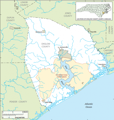
Hans Paerl, professor of marine and environmental sciences at the University of North Carolina Institute of Marine Sciences in Morehead City, is one of them. He and colleagues from UNC and other universities are preparing to publish a paper that will outline the results of a multi-year study they conducted in and around the New River, which flows as an estuary through Marine Corps Base Camp Lejeune, then enters Onslow Bay in the Atlantic Ocean through New River Inlet.
Supporter Spotlight
The overall study, funded by the government, looked at the terrestrial portion of the area as well as the aquatic, and Paerl’s portion mostly involved quantifying the carbon and nutrient flows through what’s technically called “the freshwater-marine continuum of a temperate, micro-tidal estuary.”
Carbon, of course, is the building block of life as we know it. But carbon dioxide, or CO2, the main greenhouse gas that most climate experts believe traps the Earth’s heat and is leading to significant changes in the climate, including sea level rise. And because Camp Lejeune and many other Marine Corps bases are near coastal waters – Marines are the nation’s amphibious fighters, and need to train in and around those waters – sea level rise and coastal habitat changes are important to them.
“They want to know what’s going on, on their properties and around them,” Paerl said. “And they want to know what their role is in what’s going on.”
Part of that is economic, part of it is planning.
“Many of the generals and others at the top are very forward-thinking,” Paerl said. “They can look down the road and see that at some point in the future, there might very well be carbon regulations and taxes. They want to know where they stand.”
Supporter Spotlight
In Lejeune’s case, Paerl said, the base is in pretty good standing. The study shows that 85 percent of the “nutrient budget” in the estuary – carbon is a nutrient, as are such things as nitrogen, phosphorus, potassium and calcium – comes from upstream, not from the base.

The river, which is only about 50 miles long and entirely contained in Onslow County, rises in the northwestern region and flows east-southeast past Jacksonville, where it widens into a tidal estuary about 2 miles wide. But before it gets to Jacksonville, it flows through mostly rural and agricultural land. That agriculture includes not only row crops, but also many hog farms with millions of hogs and their necessary waste lagoons. Nutrients abound.
So, Paerl said, it’s not surprising that the estuary’s nutrient load mostly comes from upstream, and the military officials are surely “delighted” to know that.
“What it means is that if we start getting more nutrient regulations, they’re in a pretty good position to show that they are not primarily responsible” for the problems that cause the need for regulations, Paerl said.
And there are plenty of examples of regulations arising from water quality problems. The state declared the Neuse River “nutrient sensitive” in the 1980s, after numerous algae blooms and fish kills, and developed and implemented rules designed to regulate sources of nutrient pollution in the basin, including wastewater, stormwater and agricultural runoff. The rules also require vegetative buffers along the water.
But beyond that, Paerl said, the Marine Corps and other branches of the military are concerned about climate change. At Camp Lejeune, they want to protect and maintain their ecosystem, because it’s similar to conditions in many areas of the world that Marines might have to fight. So they need to train in that ecosystem. Sea level rise and other ramifications of climate change could threaten those training grounds.
And, Paerl noted, military officials have long been concerned that an increasingly less stable climate with more droughts that disrupt food supplies, more major storms and continually rising sea levels, will create less stability in other countries, possibly leading to more need for U.S. intervention. They’re interested, perhaps more than most politicians these days, in limiting climate change.
What did the study find out specifically about organic, or vegetative, carbon and carbon dioxide, that predominant greenhouse gas, in the New River estuary?
Interestingly, Paerl said, it turns out that the estuary is, in general, pretty balanced between being a carbon sink, or holding carbon so it’s not released as carbon dioxide, and a contributor of CO2 to the atmosphere.
“But that can change year-to-year,” he said. It turns out that much of that variation is related to weather, which is affected by climate.
“What we’ve found is that when we have major perturbations, chiefly storms, much more CO2 is released,” Paerl said. “There were five or six major perturbations (during the study period), and we had the opportunity to look at (the effects) of those.”
What they’ve found is that “you can lose almost as much carbon to the atmosphere” from one major storm as had been stored away, or “fixed” by plants, in the estuary during the entire year in which the storm occurred.
“It’s kind like a gigantic ‘burp,’” the scientist said, that can, instantly negate a year of carbon storage by the algae and other plants.

Algae, another area of expertise for Paerl, can be terribly bad for estuaries, as it robs the water of oxygen when it decomposes, sometimes leading to fish kills. But, Paerl quipped, “I don’t think storms are really a good way to clean up our estuaries.”
At any rate, it sets up what Paerl said is a classic feedback loop.
“The more storms we have, then (based on the research) the more emissions we get,” he said. “And the more emissions we get, the more unstable the climate is likely to become, which means more storms. You have to wonder where it ends. Are we eventually to going to end up with 10 times more storms?”
It’s not, of course, “a perfectly linear world,” Paerl acknowledged, as there are other factors, such as El Nino, that influence the number of hurricanes and other storms. But you have to look at it not just from one year to the next, but decade by decade.
The New River work pretty much confirmed what previous work by Joseph Crosswell, also of UNC-IMS, found previously through work in the Neuse River, the largest tributary of the huge Pamlico Sound estuary, Paerl said.
The bottom line, he added, is that estuarine systems are very effective at holding carbon, unless disturbed. Some carbon even comes out and is “stored” by humans, through harvest and consumption of seafood.
But when those storms do hit, the negative atmospheric carbon effects can be quick, as in the windy Hurricane Irene in 2011, or slower and more sustained in the case of other, less windy storms that are mainly rainfall and flooding events.
Paerl said the overall study was funded by the Department of Defense’s Strategic Environmental Research and Development Program, and has been headed by RTI International, an independent, nonprofit research institute based in the Research Triangle Park. Other researchers have come from private companies, as well as from Duke University, the National Oceanic and Atmospheric Administration, the College of William and Mary and the Virginia Institute of Marine Science.
“It’s been a big effort, with a lot of parts,” Paerl said, and he credits the Department of Defense for being interested.
“They are really pretty good stewards of their environment, and it makes sense for them to be,” he said.
Paerl noted that the military also help preserve habitat outside the base gates by sometimes giving money to local governments to protect properties in the flight paths of Marine Corps aircraft that would otherwise be developed.
That’s happening now in Carteret County, where Emerald Isle is working with Marine Corps Air Station Cherry Point officials to get money to help pay for the purchase of 30 acres of undeveloped land behind the town hall. That property, mostly maritime forest, has been zoned for years for more than 200 condominiums, and is in the flight path of planes going to and from nearby Bogue Field, an auxiliary landing strip for Cherry Point.
If the town gets the land, it will preserve up to 20 acres of it.
“A lot of people don’t realize how much they do,” Paerl said of the Marines. “It was good to work on this project to try to help them identify what’s going on in the estuary that runs through (Lejeune).”
And, he said, the study aids the cause of science and scientific research, which has recently been under attack in some circles, because the modeling involved should be applicable to not just other coastal military installations, but to similar estuarine systems that aren’t in government hands.
“We’ve learned a lot,” he said.


