BEAUFORT – The town is one step closer to better managing stormwater runoff and improving water quality with the recent approval of the Beaufort Watershed Restoration Plan.
The Beaufort Board of Commissioners unanimously approved during its August regular meeting the voluntary plan presented by the town’s Stormwater Advisory Committee chair Whitney Jenkins, the coastal Training Program Coordinator for the North Carolina Coastal Reserve, and Mariko Polk and Lauren Kolodij, both with the North Carolina Coastal Federation.
Supporter Spotlight
This plan highlights water quality impairments in the watersheds and proposes strategies to reduce the volume of stormwater runoff to improve water quality and restore hydrology.
Jenkins began by explaining that Beaufort is experiencing water quality issues in the various watersheds, primarily due to stormwater runoff, or the water that comes off hardened surfaces such as roofs or roads during a rain event.
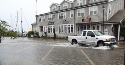
“When (rainwater) hits those hardened surfaces, it takes pollutants out into our local estuary. Those pollutants can include sediment, microbes and bacteria, as well as nutrients such as phosphorus and nitrogen,” she explained, adding that this happens often when the natural hydrology, or natural movement of water, is altered.
Furthermore, Jenkins continued, when the natural hydrology is altered, “We experience an extra pollutant load to our estuaries, and it can also cause localized flooding, which is one of the reasons why we started this Stormwater Advisory Committee here in Beaufort.”
The committee was established in January 2016 under previous town leadership. A grant was secured through the East Carolina Council to fund the process and several public meetings were held starting in June 2016. The committee also met with the town’s planning board and held a public hearing July 17 about the watershed restoration plan.
Supporter Spotlight
Jenkins said that the Division of Marine Fisheries monitors Taylor’s Creek as well as some of the other bodies of water and has determined that there is a water quality impairment due to the stormwater runoff. The increase in hardened surfaces around town has modified the natural hydrology and that has increased stormwater runoff.
“What we’re trying to do with this watershed restoration plan is turn back the clock to mimic the natural hydrology from years before, so we increase infiltration and reduce runoff,” Jenkins said.
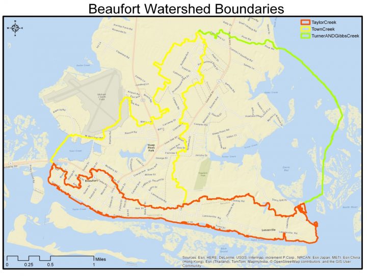
Polk, a geographic information system, or GIS, watershed specialist, who has been working on the geospatial and technical writing of the plan, reviewed with the board details about the watershed boundaries.
She said the three primary watershed boundaries identified for Beaufort are Town Creek, Taylor’s Creek and Davis Bay, which is comprised of Turner Creek and Gibbs Creek.
Polk explained that a watershed represents all of the water coming down from the highest elevation in that region to the lowest point, which are the bodies of water.
“Both go out into the Newport River and the Intracoastal Waterway, so we have very important waters, that by reducing stormwater runoff, we can help improve,” Polk said.
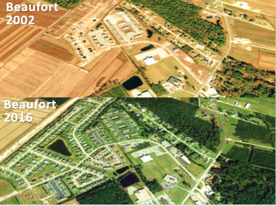
A comparison of aerial photos of the same section of Beaufort from 2002 and 2016 was presented, which Polk said shows the changes that happen naturally through the development of a town. The photo from 2016 showed a substantial amount of development, compared to the photo from 2002.
“This is showing the distinct changes in land use and how an increase in impervious surfaces normally happens with development and what we can do to alleviate the amount of stormwater runoff that comes off those impervious surfaces,” Polk said.
The aim was to determine what the volume of stormwater runoff water is being generated from that increase in impervious surface.
“We looked at 1993 imagery and compared that to 2014 and what we’re wanting to see is what that difference is,” Polk said. They also compared 2000, 2009 and 2017. “What we’re essentially wanting to do is roll back the clock … when we had less impact from stormwater runoff.”
They found that for Beaufort, the target reduction volume is about 0.08 gallons, or a couple of cups, per square foot.
The comparison was made of what happens during a one-year, 24-hour storm, which is a typical storm period seen along any coastal community in North Carolina. From that, Polk expounded, they could develop goals and objectives and specific actions that the town and community can take to reduce stormwater volume.
“What we came up with was a singular primary goal that we’re focusing on and that’s to restore the impaired water quality of the three Beaufort watersheds we’re focusing on in this plan,” Polk said, adding they’re addressing this problem from multiple perspectives.
The objectives include the following:
- Data collection and analysis conducted to accomplish the plan objectives.
- New development and redevelopment that do not create additional water quality impairments.
- Stormwater-reduction techniques that are applied on public properties.
- A reduced volume of stormwater runoff from existing private land uses.
- Periodic monitoring and review to ensure the goal and objectives of the plan are being met.
- A better educated community regarding stormwater pollution and volume-reduction needs.
- Engagement in accomplishing the plan objectives.
“Those last few objectives have to do a lot with what is called the nine minimum elements from the EPA and they are kind of standards to reach for when you’re developing a watershed restoration plan. And you want to reach those standards because once you have an approve plan, it opens the door for funding opportunities,” Polk said.
Federation Deputy Director Lauren Kolodij explained that with this plan, the focus is to mimic natural hydrology and to target projects that would either allow runoff to soak into the ground or be collected for later use, or disperse the management measures throughout the site.
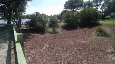
Kolodij said the effort goes beyond conventional stormwater ponds. She cited examples in Beaufort such as the rain gardens at Tiller School and at the Lennoxville Boat Ramp, or Curtis Perry Park where Front Street and Lennoxville Road meet, as well as the permeable pavement at Beaufort Fire Department.
She also detailed the various stormwater techniques at Pivers Island that will be used for research and showcased to the public and students as examples of how to reduce stormwater. There are at Pivers Island a series of bio-retention areas, stormwater wetlands, permeable pavement, rainwater harvesting, native landscaping and living shorelines … “These are techniques that we are really promoting with the plan.”
With the nearly completed bridge and roadway construction in Beaufort bringing significant changes to the area, Kolodij suggested ways to collect or direct runoff on roads by making depressions and curb cuts. She provided ideas used by other towns that have implemented watershed restoration plans.
The plan seeks to restore and maintain the water quality and reduce instances of localized flooding, Kolodij said. “We want to prioritize cost-effective stormwater projects, … we want to increase community awareness … and we hope to do an educational campaign with the town of Beaufort.”
“When you adopt a plan like these voluntary restoration plans, it positions the town to apply for and hopefully secure funding,” she concluded before thanking town officials, the committee and other partners in the process, including Beaufort Planning Director Kyle Garner.
“We’re extremely pleased with the work that the North Carolina Coastal Federation and East Carolina Council has done with the development the of the watershed restoration plan,” said Garner. “I see this as a great opportunity for us when applying for potential grants to aid in implementing the objectives of the plan.”
Garner added that now that the watershed restoration plan has been approved, the town can move forward with working on areas in need of improvement.
Jenkins explained after the meeting that having the approval from the board gives the advisory committee “clear milestones to work toward to help the town reduce stormwater pollution reaching local waters and alleviate flooding. At our next committee meeting Sept. 13, we’ll discuss the future direction of the committee and how we can help secure grant funding to begin plan implementation.”


