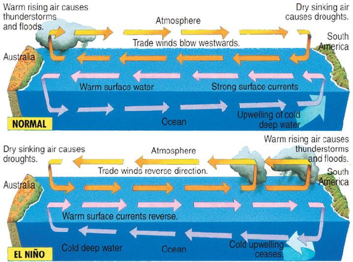
Along much of the North Carolina coast, the first week of March was ushered in by intermittent rain and fog, with a stiff, offshore breeze. But on the other side of the world, in the Pacific Ocean, the trade winds were dying. When they revived, instead of blowing east to west, their usual direction, they reversed in strong bursts.
This about-face and a confluence of other meteorological events have triggered one of the strongest El Niños seasons since 1950. It is likely to peak in late fall and early winter before ending next spring. As a result, the Pacific has spawned eight hurricanes and 11 typhoons, while the Atlantic has experienced a quiet season. In fact, Currituck, Camden, Pasquotank and Perquimans counties are classified as abnormally dry by the N.C. Drought Monitor.
Supporter Spotlight

It’s unclear whether natural forces alone have contributed to the intensity of the 2015 El Niño. The atmosphere in the Pacific may naturally vary, or the system could be destabilized by other external forces. “There’s not a consensus on how human impacts affect an El Niño,” says Phil Klotzbach of the Tropical Meteorology Project at Colorado State University, who writes the seasonal hurricane forecasts. “That’s a huge question. We don’t fully understand the physics of what drives an El Niño.”
We do know they tend to occur every two to seven years, and last from nine to 12 months. An El Niño begins when trade winds, having weakened or reversed course, generate a Kelvin wave, a deep sloshing beneath the ocean’s surface. In the last nine months, three Kelvin waves have crossed the Pacific. Each one has lumbered eastward along the equator on a three-month journey from Indonesia to South America. It has dragged warm water with it, increasing sea surface temperatures in the central and eastern Pacific—as much as 3.6 degrees this year.
These warm waters release more heat into the atmosphere, causing the air to rise and sparking storms. Larger circulation patterns in the atmosphere alter the jet stream, calming the weather patterns in the Atlantic basin more than 5,000 miles away.
“When the air rises one place, it sinks in another,” Klotzbach says. “Rarely does the entire globe go crazy.”
In a typical Atlantic hurricane season, the 30-year average calls for 12 named storms, including six hurricanes, — two of them major—although these systems may not affect the U.S. mainland.
Supporter Spotlight
Historical data, though, points to a correlation between El Niño events and a lower number of Atlantic hurricanes and tropical storms:
- In 1982, considered a strong El Niño year, meteorologists recorded less activity: just six tropical storms, two hurricanes and one major hurricane in the Atlantic.
- In 1997, also a strong El Niño season, there were eight tropical storms, three hurricanes and one major hurricane.
- The last El Niño, classified as moderate, occurred in 2009. There were nine tropical storms, three hurricanes and two major hurricanes.
So far, this year’s season has logged four tropical storms:
- Ana, which made landfall as a tropical storm near Myrtle Beach, S.C.;
- Bill, which came ashore in Texas, causing coastal and inland flooding;
- Claudette, which did not affected the United States and brought only showers and wind to eastern Nova Scotia and Newfoundland;
- and Erika, which dissipated before it reached Florida, where it dropped heavy rain.

As for hurricanes, strong wind shear quashed two storms before they approached the East Coast. A Category 1, Hurricane Fred died after moving through the Cape Verde Islands; and Hurricane Danny peaked at Category 3 before reaching the Leeward Islands.
“They died a glorious death in the middle of the ocean,” Klotzbach says.
This season, hurricane forecasters have estimated the chance for a hurricane to affect North Carolina at 14 percent, compared to the average probability of 28 percent. For a major hurricane, the chances drop to 3 percent, compared to the average of 8 percent.
Hurricane season officially ends Nov. 30.
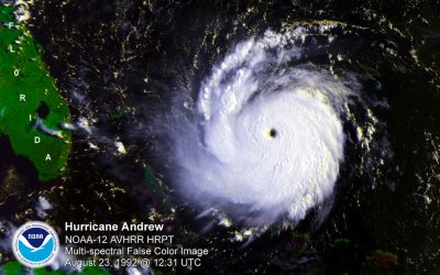
However, just because chances are lower than average does not mean that a hurricane cannot strike North Carolina. State climatologist Ryan Boyles notes that 1992 was also an El Niño year, and only one hurricane hit the East Coast. That storm was Hurricane Andrew, which destroyed 63,000 homes and damaged more than 100,000 others in Miami-Dade County, Fla. At least 65 people died. At the time, Hurricane Andrew was the costliest in history, causing $2.6 billion in damage.
“Very few people make planning decisions based on seasonal forecasts,” Boyles says.
“It only takes one, and that’s what we prepare for,” says Julia Jarema, communications officer for N.C. Emergency Management.
Gabe Vecchi is the head of the Climate Variations and Predictability Group at NOAA’s Geophysical Fluid Dynamics Laboratory at Princeton University. He says several factors could influence an active El Niño season, and thus a calm Atlantic basin. “It’s hard to point to one thing,” he said. “There’s more than one actor involved.”
One factor is the Atlantic Multi-decadal Oscillation, the AMO for short. This circulation pattern runs in 25-to-30-year cycles, and affects sea surface temperatures and sea level pressure—and by extension, hurricane formation. From the 1960s to the first half of the 1990s, the AMO phase cooled the oceans, and there was comparatively less intense hurricane activity. Then in 1995, Boyles says, “things flipped” and we’ve had warmer ocean waters—and more hurricanes—since, although that pattern could be changing.
Scientists are still trying to understand how the AMO behaves. It appears to be linked to regional and global climate trends, according to NOAA. It is driven by swings in temperatures in the “Atlantic conveyer belt” or major ocean currents like the Gulf Stream, off the N.C. coast that move warm surface water north to higher latitudes or cold northern waters south.
The conveyor belt, though, is sensitive to salinity levels in the ocean, a NOAA study reports. Those salinity levels can vary depending on water evaporation—which increases the ocean’s saltiness—or “freshening,” which decreases it. Lower salinity equals cooler temperatures and less frequent hurricanes.
What causes the ocean to lose its salt? A melting of the ice pack, ocean circulation patterns and rain can all dilute salinity. This, what NOAA called the “Great Salinity Anomaly” occurred in the mid-1960s and lasted for roughly 25 to 30 years.
For the past 20 years until recently, the pattern seems to have reversed, and the waters near Greenland have become saltier. Salinity levels appear to be decreasing again. This contributes to a cooling of the waters in the North Atlantic and a warming in the South—a pattern that began last November.
That cooling, plus higher air pressure, stronger wind shear, volcanic ash and even dust blowing off Africa, dampens hurricane formation.
“We’re not sure the AMO is fully natural in its occurrence,” Vecchi says.
The strongest El Nino on record may be forming in the Pacific Ocean. A “Godzilla” El Nino, one forecaster called it. That, of course, set off the breathless reporting seen in this YouTube video compiled by SignsofThyComing, which we assume to be one of those END OF THE WORLD IS NEAR sort of places.
Over the last century, greenhouse gases have warmed the planet, which could affect the strength of the AMO. Deforestation and farming practices can produce more dust and pollution. “All these ingredients: how much does each one do?” Vecchi says.

An anomaly has also appeared in the Pacific Ocean that has contributed to a stormy Hawaiian summer. This is the second consecutive year that warmer waters have approached Hawaii, which usually is insulated from hurricanes by cooler waters around the island. However, on July 12, satellite imagery showed five named tropical cyclones queued up from Mexico to Japan.
Scientists are studying an unusual formation—what Klotzbach calls a “previously unobserved” band of extremely warm water—north of the equator, stretching from western Mexico to near Hawaii.
El Niño conditions likely contributed to the band’s formation, but Vecchi says, “It’s not part of the El Niño; it’s a neighbor of El Niño. It’s not typical. This hasn’t occurred with other El Niños.”
By next March, the El Niño will likely begin to lose steam. Warmer waters, carried from the western Pacific, will spread east and toward the poles. When this happens, deeper, cooler ocean waters move closer to the surface.
However, it’s difficult to predict how the end of the El Niño will affect next summer’s Atlantic hurricane season. “There have been big advances, but there is always going to be inherent uncertainty,” Vecchi says.
Boyles, the state climatologist, says the science still needs better observation data and more powerful computers. “We still don’t understand how hurricanes develop and intensify,” he says. “We don’t know the state of the atmosphere.”


