This story was reprinted from the Island Free Press.
Social media, weather websites and television have been jammed the last few days with speculation that a subtropical or tropical storm could form in the area of the Bahamas today or tomorrow and threaten the N.C. coast with nasty weather by week’s end — almost a full month before the official beginning of the hurricane season.
Supporter Spotlight

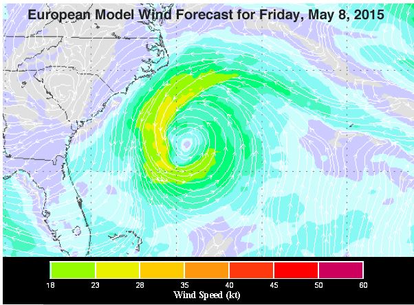
Forecasters are looking at low pressure forming along the remnants of a dying cold front in the western Atlantic between Cuba and the Bahamas over the next few days. Some computer models are suggesting that the low pressure could take on tropical or subtropical characteristics by the end of the week.
If this system does become tropical or subtropical, it will be named Ana.
Jeff Masters, a meteorologist and the co-founder of Weather Underground, wrote on his blog yesterday that, “The first week of May is usually too early for the Atlantic to see its first named storm.”
Weather Underground’s top forecasting computer models predict the storm will form a well-defined center today, Masters wrote, then drift slowly northwards towards North Carolina during the week, gradually acquiring tropical characteristics.
“Ocean temperatures are near 26°C (79°F), which is about 1.7°C (3°F) above average for this time of year, and just at the limit of where a tropical storm can form,” he wrote. “If the storm manages to find a sweet spot over the core of the warm Gulf Stream current, it has the potential to develop into a subtropical or tropical depression late in the week.”
Supporter Spotlight
No matter what the eventual path and strength of the low pressure, forecasters say that the Outer Banks could see indirect effects late in the week, including gusty winds, heavy seas, rip currents and perhaps rain.
The Outer Banks’ east-facing beaches were beat up again over the weekend by gusty northerly winds and heavy seas in the wake of a cold front that passed through the area on Friday.

Large waves at high tide during a full moon took a toll on the north Buxton oceanfront, where six houses have already been declared “unsafe” for habitation. Waves beat on the oceanfront structures again and water rushed through the streets behind the breached dunes.
On the northern Outer Banks, the N.C. Department of Transportation, or DOT, closed a section of N.C. 12 at the end of Kitty Hawk Road early Saturday after waves from the storm washed away 500 feet of dune in this area, as well as sand from under the road. DOT recognized the safety hazard and closed the road in advance of any possible collapse. A portion of the northbound lane did collapse Saturday evening, resulting in 200 feet of pavement damage.
DOT began temporary repairs on Monday after the waves had calmed. In order to open the road to traffic, crews will remove all damaged pavement and refill the area back up with sand. Once the sand is in place, they will then pave the area so traffic can be restored as soon as possible. The department currently expects the road to reopen to traffic by the end of the week.
While this is going on, DOT staff will work on preparing plans and acquiring necessary permits for the reconstruction of the dune. A timeframe for reconstruction is not available at this time.
N.C. 12 is currently closed to through traffic between White Avenue and East Balchen Street in Kitty Hawk. Local traffic can access houses and businesses along the road within the closure limits, but cannot cross the area where the damage took place. Through traffic will continue to use a signed detour.
Carin Goodall, a meteorologist at the National Weather Service in Newport, said, it’s not unusual to see low pressures like this one forming off the coast before hurricane season.
According to weather records dating back to 1851, 25 hurricanes, including tropical storms and depressions, have formed in the Atlantic basin before June 1. The last time this happened was in 2012 when two tropical systems formed in May — Alberto and Beryl. Beryl came ashore in north Florida as a tropical storm after meandering around in the ocean.
Tess Malijenovsky, staff writer for Coastal Review Online, contributed to this story.


