One of the flashpoints in the debate over developing possible offshore oil and gas centers on seismic surveying, an effective but controversial method used in the search for energy deposits.
Three public meetings will be held along the coast this month, with the first scheduled for today in Wilmington, about using “air guns” off the N.C. coast.
Supporter Spotlight
Here’s a primer to help you understand what all the noise is about.
What is seismic surveying?
It’s an exploration method that uses pulses of sound that are projected into the earth’s crust. As the sound rebounds, the pulses are analyzed and from that data images of the layers of sediment, rock and hydrocarbons up to 10,000 feet below the surface can be created.
The technology is used to search for hydrocarbons on land and in marine environments. It is also used by doctors when giving utrasound examinations to pregnant women.
Is this a new technique?
Supporter Spotlight
Not really. Land-based seismic surveying has been in use since the 1920s, although the early methods used to create the pulses of sound would be considered downright primitive by today’s standards—the survey team would set off dynamite at the bottom of a shaft they had drilled.
Marine seismic surveying was developed in the 1960s. Technology had advanced to the point that a method of sending a bubble of sound to the bottom of the ocean had been developed and the returning sound waves could be interpreted by the improving computer technology.
How does marine seismic surveying work?
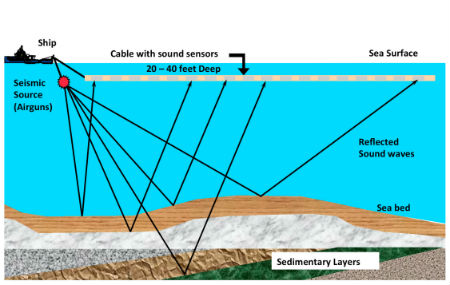
An array of “air guns” are towed behind a ship and at timed intervals a pulse of sound is directed to the seabed. The term air gun may not be quite correct, though, according to Stanley Labak, an expert in marine acoustics with the Bureau of Ocean Energy Management, or BOEM. That’s the federal agency that regulates offshore energy exploration and production
“Air gun is the terminology in the industry since its inception . . . in the early ‘60s. But it’s not really a gun. It’s a chamber that has pressurized air in it and at a set time they release that air and it forms a bubble and it creates sound,” he said.
The pulses of sound penetrate the ground and as the echoes of the sound come back to the ship they are analyzed. From the data the returning pulses of sound create a remarkably detailed map of the earth beneath the ocean floor.
Why is it needed?

Currently, there is no alternative technology that maps the seabed and the resources that may there. To potential bidders planning to participate in BOEM’s planned sale of oil and natural gas leases off the N.C. coast, the information seismic surveying can provide is considered critical.
Why are some people opposed to it?
Because all marine mammals and many other species of marine life use sound to communicate and navigate the oceans, many people are worried that the sound coming from the air guns will harm whales, dolphins, sea turtles and fish. The pulse of sound is very loud, typically between 200-300 decibels. To put that in perspective, normal conversation occurs at about 60 decibels; the noise of a passing truck is about 100 decibels; and the roar of a jet at takeoff is around 180 decibels.
Is there any evidence that any of these fears are real?
Here is where it gets a bit confusing.
There are no peer-reviewed studies that have shown a definitive link between seismic surveying and injured or dead marine life. However, there have been a considerable number of incidental events where seismic surveying has occurred that coincides with changes in behavior in marine life and large increases in dead animals.
Advocates for seismic surveying point out that the wave length of the sounds are well below threshold of what almost all marine mammals can hear—higher frequencies will not penetrate beneath the seabed. They also argue that very little sound escapes from the air gun pulses, noting that the more focused the pulse is the more accurate and useful the rebounding echo will be.
Opponents observe that laboratory tests on marine life subjected to sounds similar to those emitted during seismic surveys are adversely affected and there is a considerable body of evidence pointing to injured and dead marine life occurring during seismic surveying.
A 1996 study in Norway showed a marked decrease in fish catch over a 2,000 square-mile area following seismic surveying. There are also, worldwide, well-documented beachings of whales and dolphins concurrent with survey activity.
Am I likely to hear the booms while walking the beach or fishing offshore?
Highly unlikely, although anything is possible. Because the seismic surveying that is being contemplated is so far offshore—a minimum of three miles for oil and gas—there is no possibility that the sound would travel back to the shore. If a seismic survey was done closer to shore and in shallower water, it is possible that the pulse could bounce off the bottom and be heard along the shoreline.
What’s being proposed for North Carolina?
The continental shelf off the North Carolina coast is clearly in the bullseye of where oil and gas are thought to exist.
There are two basic types of seismic surveying: two dimensional and three dimensional. A 2D survey is really an outline of an area where the possibility of oil or gas is thought to exist. A 2D survey consists of a ship with a single pulse source sailing a grid pattern. The survey information is less detailed but also takes less equipment and expertise to interpret.
The 3D array, which provides more detailed information, requires multiple air guns on towlines behind the survey ship.
There are permit requests for 2D- and 3D-surveys in N.C. waters.
Have state and federal permits been issued?
Getting a permit to engage in what’s called “geological and geophysical,” or G&G, surveying is a time consuming and detail-oriented process. Because the areas under consideration are not within the three-mile jurisdiction of the state, there are no state permits required.
However, the state has a federally approved coastal management program. That allows the state to review any action that requires federal permits to make sure it’s consistent with state laws and regulations. BOEM couldn’t immediately issue permits for seismic testing if the state officials determined that it would violate the state program.
BOEM in February of 2014 issued a so-called Record of Decision outlining what the government will be seeking in a G&G permit application. A detailed recital of mitigations and precautions, the document is 12 pages long.
No seismic surveying permits have been issued, although there are currently four permit requests. Petroleum Geo-Services has requested a 3D permit. Spectrum GEO, WesternGeco and GX Technology have asked for 2D permits.
The 3D permit request is the only such request on the Eastern seaboard.
When will it start?
It’s difficult to say when or even if seismic surveying will begin. It is possible that BOEM will move quickly after the public hearings and seismic surveying could begin as early as this summer. It is also possible that the concerns of the public and problems with the permit applications will slow the process down, or bring it to a halt.
Public Meetings Scheduled for April
People can learn about offshore seismic testing at three public meetings this month along the N.C. coast. Two are sponsored by the federal Bureau of Offshore Energy Management, or BOEM, and one by the state Division of Coastal Management, or DCM.
Today in Wilmington: Hilton Wilmington Riverside, 301 N. Water St. One meeting starts at 3 p.m. and the other at 5:30 p.m. Each lasts about 90 minutes. Sponsored by BOEM.
Thursday in Morehead City: Crystal Coast Civic Center, 3505 Arendell St. The meeting starts at 5 p.m. and lasts four hours. Sponsored by DCM.
April 27 in Kill Devil Hills: Ramada Plaza Nags Head Oceanfront, 1701 S. Virginia Dare Trail, Kill Devil Hills. One meeting starts at 3 p.m. and the other at 5:30 p.m. Each lasts about 90 minutes. Sponsored by BOEM.


