SUNSET BEACH — A controversial proposal that would loosen development rules on land where a tidal inlet once separated Sunset Beach from Bird Island will again be considered by the state Coastal Resources Commission when it meets next month.
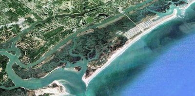
Mad Inlet, a shallow channel that meandered between the Brunswick County town and the now-protected coastal reserve, was designated years ago by the N.C. Division of Coastal Management as an “inlet hazard area,” vulnerable to the elements and not stable for most development.
Supporter Spotlight
More than a decade after the inlet dried up in the early 1990s, affixing the undeveloped island to the west end of Sunset Beach, the division’s science panel, a group of coastal engineers and geologists, recommended removing the land from the inlet hazard area designation.

Th developed Sunset Beach, upper right, was once divided from the now protected Bird Island by a narrow, meandering inlet. |
The proposal was made in May 2010 following a study of the state’s 12 developed inlets. The report suggests that the inlet hazard boundaries be removed from Mad Inlet and Corncake Inlet, which once flowed past Fort Fisher to the marshes of Bald Head Island.
Coastal management and the science panel, “determined that the threat of these two inlets reopening is no higher than the creation of new inlets through the breaching process associated with storms that historically have occurred along the state’s barrier islands,” according to the report.
“We’re going through the rule-making process now,” said Michelle Walker, the division’s public information officer. “We recommended, based on the science panel recommendation, to remove the IHA from that area and instead designate it as an ocean erodible area. These are both types of areas of environmental concern.”
Supporter Spotlight
An Ocean Erodible Area includes the state’s beaches oceanfront land affected by long-term erosion. Re-designation from an IHA to an Ocean Erodible AEC would allow for more dense development and larger structures.
Sunset Beach officials and residents and the N.C. Coastal Federation objected to the recommendation, citing concerns the inlet could reopen and that the land is unsuitable for intense development.
The Sunset Beach Town Council in early December passed a resolution opposing the proposal, stating, in part, that several beach towns are examining whether to install terminal groins to curb beach erosion.
“The Town Council feels there is a probability that Mad Inlet could reopen, given the amount of sand movement that will be experienced if terminal groins are installed in neighboring communities,” the resolution reads.
Sunset Beach resident Sue Weddle has been a staunch opponent of the proposal.
“There are over 40 acres of land that have developed as a result of the inlet closing. It could be built on from the end of Sunset Beach to where the end of the Bird Island Conservation starts,” she said. “It’s really a bad idea.”
The Mad Inlet Hazard Area is designated by the Federal Emergency Management Agency as a “VE” flood zone. “V” zones are considered the most hazardous of FEMA’s Special Flood Hazard Area, and generally include the first row of beachfront properties. Flood insurance is mandatory in these zones.
That may be a pose a problem for potential buyers if the land is developed. The property is a Coastal Barrier Resources Act zone, a federal designation that prohibits property owners from receiving federal funding and financial assistance.

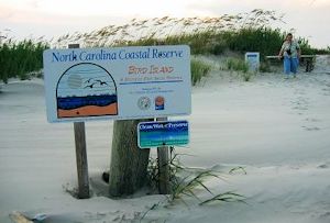
The northern boundary of the Bird Island Coastal Reserve borders land that could be developed if the inlet hazard rules were eliminated. |
Residents and local communities are theoretically responsible for covering the costs from storm damage.
The state’s 2010 analysis, Weddle said, does not consider that 30 to 40 oceanfront lots could be developed to the boundary of the Bird Island Coastal Reserve.
“It is the development of these lots that would seriously affect the Bird Island Conservation Reserve and the sitting property owners on the built-out Sunset Beach oceanfront and built-out properties on 40th Street by a change in the inlet hazard designation,” she said. “Building out there is just a disaster waiting to happen.”
The federation has taken a similar stance on the matter. In a letter to Braxton Davis, the director of the Division of Coastal Management, the federation points out that, though Mad Inlet has been closed for years, “the area remains a zone of weakness and an inlet could reopen with the next major storm.”
The federation challenges the study’s conclusion that the inlet is not expected to reopen and asks the CRC to evaluate scientific criteria that would determine whether an inlet will remain closed.
“Development of the IHA would threaten critical habitat and increase the likelihood of further beach erosion and potential loss of nesting sites for birds and turtles,” the letter states.
The inlet has repeatedly opened and closed throughout the past two centuries, a point made to the CRC in a 1995 briefing by a geologist and former director of the University of North Carolina Institute of Marine Sciences.
In September 2010, the CRC unanimously voted to amend the proposed rule and open a public hearing on the matter. The following November, the CRC suspended any decision to designate new IHAs until a study of coastline erosion rates was completed.
The Division of Coastal Management held a public hearing Nov. 6 last year in Sunset Beach on the proposed rule amendment to remove the IHA designation. A majority of those who attended the hearing spoke in opposition to the proposal.
The division accepted public comments on the proposed rule change until Dec. 12, one day after the CRC’s final meeting of 2013 commenced. The commission tabled a decision on the rule.
CRC Chairman Frank Gorham said the commission wanted a statement from the science panel at the commission’s next meeting Feb. 26-27 in Nags Head.


