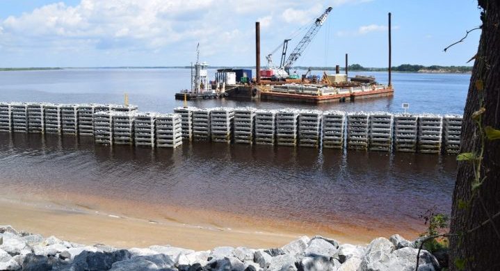
WINNABOW – The first installment of structures designed to keep waves from eating away shoreline rise out of the Cape Fear River along a section of the already battered banks of the Brunswick Town/Fort Anderson State Historic Site.
Like sentries standing post, a line of structures described as wave attenuators stretches 200 feet just offshore of Dry’s Wharf, one of three wharves on the grounds of a once bustling Colonial port town that was later turned into a Civil War fort as part of the Confederate army’s river defense of Wilmington.
Supporter Spotlight
The “reefmakers,” created by Alabama-based Walter Marine, the largest artificial reef builder in the U.S., look simple enough. Each structure is made using a series of square, concrete discs stacked together that create large, slotted blocks. Each disc is topped with embedded rocks that jut up like eggs in an egg carton.
This design does the complex job of taking the brunt of wave energy while allowing water to flow through, protecting the shore and, at the same time, offering habitat for marine life. Each block sits about a foot off the riverbed.
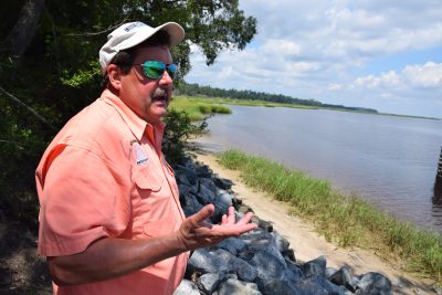
“There’s already schools of bait fish coming around this thing,” said Randy Boyd, an engineer with Atlantic ReefMaker, which installed the wave attenuators.
The wall-like structure rising about 4 feet above the river is the first in a multi-phase project to protect the site’s more than 5,000 feet, nearly a mile, of shoreline.
Brunswick Town/Fort Anderson is roughly halfway between the mouth of the Cape Fear River and the North Carolina Port of Wilmington.
Supporter Spotlight
Large ships traveling to and from the port create wakes, or turbulent waves that crash onto shore. This high-energy wave environment paired with storm surge from hurricanes and other coastal storms has severely eroded the shoreline, damaging and destroying irreplaceable artifacts.
Researchers at the University of North Carolina Wilmington have reviewed and compared aerial photographs of the site dating back to the 1930s. Those photos show that since 2006, the historic site’s waterfront has receded upward of 70 to 120 feet.
The multi-million-dollar shoreline protection project was designed by a team of experts, including Boyd, with environmental engineering firm SEPI Engineering and Construction. It took SEPI more than a year to obtain the state Coastal Area Management Act, or CAMA, major permit for the project, which combines the protection of reefmakers with the construction of a living shoreline. Living shorelines use plantings and constructed oyster reefs to stabilize and protect the actual shoreline from erosion and restore marine life habitat.
Original plans to place wave attenuators along another section of shoreline were altered after Hurricane Matthew, which hit North Carolina nearly a year ago, cut about a 14- to 15-foot gap out of Dry’s Wharf. The wharf is named after Capt. William Dry, a Colonial merchant, justice of the peace and militia captain.
“We were limited per linear foot by what we would have been able to have done per funding,” Boyd said.
The total price tag ran about $750,000.
Boyd said he hopes to eventually connect the existing structure to more wave attenuators. The next structures, Boyd said, will be octagonal and installed not side-by-side, but rather like a zipper pattern.
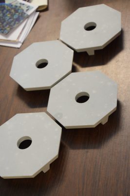
“We’re really looking forward to putting in the octagonals,” he said. “We think it’s going to make a hell of a difference. The beauty of this site is that I’ve got four completely different shorelines.”
While wave attenuators will front some of the more than mile-long shore, the living shoreline will be constructed along other portions.
In the meantime, researchers at UNCW are monitoring the project using sensors to track wave activity in front of and behind the structure.
“We’re going to look at these things through hurricane season,” Boyd said.
It is unclear when the next phase will get underway.
“We’re applying for various grants and hoping we’ll be able to get a significant amount,” said Jim McKee, Brunswick Town site manager.
McKee has said he prefers a living shoreline to a hardened erosion-control structure because the former is a natural method of protecting valuable resources.
McKee kept a close eye on the reefmakers as the remnants of Hurricane Irma swept north after making landfall in southern Florida.
“Where the reefmakers are, it did great,” he said.
As of Tuesday afternoon, McKee said he had not had the opportunity to check whether Irma’s driving winds and rain had damaged other areas of the shore.
As he took stock of how the shoreline had fared, McKee said he was also keeping an eye on Hurricane Jose, which was on a wobbly track well off the East Coast on Wednesday.


